
Topografische kaart Waltham
Interactieve kaart
Klik op de kaart om de hoogte weer te geven.
Over deze kaart
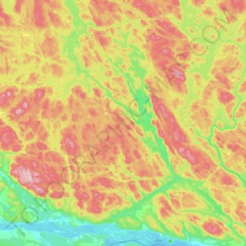
Naam: Topografische kaart Waltham, hoogte, reliëf.
Locatie: Waltham, Pontiac, Outaouais, Quebec, J0X 3H0, Canada (45.89225 -77.04870 46.16432 -76.79797)
Gemiddelde hoogte: 245 m
Minimale hoogte: 104 m
Maximale hoogte: 409 m
Its territory, with a maximum elevation of just over 350 metres (1,150 ft), is sparsely populated, the majority of the population living along or near the Ottawa River. The northern portion is a vast extended tract of undeveloped land, dotted with lakes, such as Findlay, Landon, Gagnon, and Caughlin, which are popular for fishing.
Andere topografische kaarten
Klik op een kaart om zijn topografie, zijn hoogte en zijn reliëf te bekijken.
Greer Mount
Canada > Quebec > Pontiac > Thorne
Greer Mount, Thorne, Pontiac, Outaouais, Quebec, Canada
Gemiddelde hoogte: 261 m
Lac Rueckwald
Canada > Quebec > Pontiac > Thorne
Lac Rueckwald, Thorne, Pontiac, Outaouais, Quebec, Canada
Gemiddelde hoogte: 223 m
Bristol Mines
Canada > Quebec > Pontiac > Bristol
Bristol Mines, Bristol, Pontiac, Outaouais, Quebec, J0X 1G0, Canada
Gemiddelde hoogte: 93 m
Lac Sopwith
Canada > Quebec > Pontiac > Otter Lake
Lac Sopwith, Otter Lake, Pontiac, Outaouais, Quebec, Canada
Gemiddelde hoogte: 275 m
L'Isle-aux-Allumettes
L'Isle-aux-Allumettes, Pontiac, Outaouais, Quebec, Canada
Gemiddelde hoogte: 148 m
Lac Antiquois
Canada > Quebec > Pontiac > Lac-Nilgaut
Lac Antiquois, Lac-Nilgaut, Pontiac, Outaouais, Quebec, Canada
Gemiddelde hoogte: 366 m
Otter Lake
Otter Lake, Pontiac, Outaouais, Quebec, J0X 2P0, Canada
Gemiddelde hoogte: 262 m
Danford Lake
Canada > Quebec > Pontiac > Alleyn-et-Cawood
Danford Lake, Alleyn-et-Cawood, Pontiac, Outaouais, Quebec, J0X 1P0, Canada
Gemiddelde hoogte: 210 m