
Topografische kaart Clarendon
Interactieve kaart
Klik op de kaart om de hoogte weer te geven.
Over deze kaart
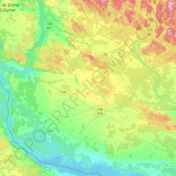
Naam: Topografische kaart Clarendon, hoogte, reliëf.
Locatie: Clarendon, Pontiac, Outaouais, Quebec, Canada (45.51357 -76.66755 45.74936 -76.36126)
Gemiddelde hoogte: 152 m
Minimale hoogte: 72 m
Maximale hoogte: 321 m
Andere topografische kaarten
Klik op een kaart om zijn topografie, zijn hoogte en zijn reliëf te bekijken.
Greer Mount
Canada > Quebec > Pontiac > Thorne
Greer Mount, Thorne, Pontiac, Outaouais, Quebec, Canada
Gemiddelde hoogte: 261 m
Lac Rueckwald
Canada > Quebec > Pontiac > Thorne
Lac Rueckwald, Thorne, Pontiac, Outaouais, Quebec, Canada
Gemiddelde hoogte: 223 m
Bristol Mines
Canada > Quebec > Pontiac > Bristol
Bristol Mines, Bristol, Pontiac, Outaouais, Quebec, J0X 1G0, Canada
Gemiddelde hoogte: 93 m
Lac Sopwith
Canada > Quebec > Pontiac > Otter Lake
Lac Sopwith, Otter Lake, Pontiac, Outaouais, Quebec, Canada
Gemiddelde hoogte: 275 m
L'Isle-aux-Allumettes
L'Isle-aux-Allumettes, Pontiac, Outaouais, Quebec, Canada
Gemiddelde hoogte: 148 m
Lac Antiquois
Canada > Quebec > Pontiac > Lac-Nilgaut
Lac Antiquois, Lac-Nilgaut, Pontiac, Outaouais, Quebec, Canada
Gemiddelde hoogte: 366 m
Otter Lake
Otter Lake, Pontiac, Outaouais, Quebec, J0X 2P0, Canada
Gemiddelde hoogte: 262 m
Danford Lake
Canada > Quebec > Pontiac > Alleyn-et-Cawood
Danford Lake, Alleyn-et-Cawood, Pontiac, Outaouais, Quebec, J0X 1P0, Canada
Gemiddelde hoogte: 210 m