
Topografische kaart South Uist
Interactieve kaart
Klik op de kaart om de hoogte weer te geven.
Over deze kaart
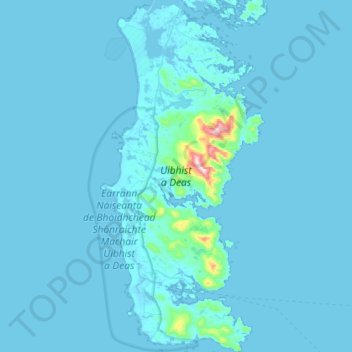
Naam: Topografische kaart South Uist, hoogte, reliëf.
Locatie: South Uist, Western Isles, Scotland, United Kingdom (57.09553 -7.45826 57.40633 -7.19180)
Gemiddelde hoogte: 15 m
Minimale hoogte: -2 m
Maximale hoogte: 596 m
In the north west of the island at (57°20′N 07°20′W / 57.333°N 7.333°W / 57.333; -7.333), a missile testing range was built in 1957–58 to launch the Corporal missile, Britain and America's first guided nuclear weapon. This development went ahead despite significant protests, some locals expressing concern that the Scottish Gaelic language would not survive the influx of English-speaking Army personnel. The British Government claimed that there was an 'overriding national interest' in establishing a training range for their newly purchased Corporal, a weapon that was to be at the front line of Cold War defence. The Corporal missile was tested from 1959 to 1963, before giving way to Sergeant and Lance tactical nuclear missiles. The 'rocket range' as it is known locally has also been used to test high-altitude research rockets, Skua and Petrel. Local opposition to the range inspired the 1957 novel Rockets Galore by Compton Mackenzie.
Andere topografische kaarten
Klik op een kaart om zijn topografie, zijn hoogte en zijn reliëf te bekijken.
Callanish
United Kingdom > Scotland > Western Isles
Callanish, Western Isles, Scotland, HS2 9DY, United Kingdom
Gemiddelde hoogte: 19 m
Scarista
United Kingdom > Scotland > Western Isles
Scarista, Western Isles, Scotland, HS3 3HX, United Kingdom
Gemiddelde hoogte: 60 m
Askernish
United Kingdom > Scotland > Western Isles
Askernish, Western Isles, Scotland, HS8 5RX, United Kingdom
Gemiddelde hoogte: 11 m
Steall Abhainn na Cloich
United Kingdom > Scotland > Western Isles
Steall Abhainn na Cloich, Western Isles, Scotland, HS2 0NN, United Kingdom
Gemiddelde hoogte: 44 m
Carloway
United Kingdom > Scotland > Western Isles
Carloway, Western Isles, Scotland, HS2 9AU, United Kingdom
Gemiddelde hoogte: 46 m
Cuddy Point
United Kingdom > Scotland > Western Isles > The Village
Cuddy Point, The Village, Western Isles, Scotland, HS4 3YD, United Kingdom
Gemiddelde hoogte: 33 m
Lewis
United Kingdom > Scotland > Western Isles
Lewis, Western Isles, Scotland, United Kingdom
Gemiddelde hoogte: 42 m
Hirta
United Kingdom > Scotland > Western Isles
Hirta, Western Isles, Scotland, United Kingdom
Gemiddelde hoogte: 58 m
Reef
United Kingdom > Scotland > Western Isles
Reef, Western Isles, Scotland, HS2 9HU, United Kingdom
Gemiddelde hoogte: 18 m
Boreray
United Kingdom > Scotland > Western Isles
Boreray, Western Isles, Scotland, HS6 5AJ, United Kingdom
Gemiddelde hoogte: 4 m
Port of Ness
United Kingdom > Scotland > Western Isles
Port of Ness, Western Isles, Scotland, HS2 0XA, United Kingdom
Gemiddelde hoogte: 19 m
Kennavay
United Kingdom > Scotland > Western Isles
Kennavay, Western Isles, Scotland, HS4 3YG, United Kingdom
Gemiddelde hoogte: 9 m
Sandwick
United Kingdom > Scotland > Western Isles
Sandwick, Western Isles, Scotland, HS2 0AG, United Kingdom
Gemiddelde hoogte: 7 m
North Uist
United Kingdom > Scotland > Western Isles
North Uist, Western Isles, Scotland, United Kingdom
Gemiddelde hoogte: 10 m
Barra
United Kingdom > Scotland > Western Isles > Northbay
Barra, Northbay, Western Isles, Scotland, United Kingdom
Gemiddelde hoogte: 27 m
Balivanich
United Kingdom > Scotland > Western Isles
Balivanich, Western Isles, Scotland, HS7 5LQ, United Kingdom
Gemiddelde hoogte: 3 m
Loch Langavat
United Kingdom > Scotland > Western Isles
Loch Langavat, Western Isles, Scotland, United Kingdom
Gemiddelde hoogte: 96 m
Stornoway
United Kingdom > Scotland > Western Isles
Stornoway, Western Isles, Scotland, HS1 2DB, United Kingdom
Gemiddelde hoogte: 34 m
Linshader
United Kingdom > Scotland > Western Isles
Linshader, Western Isles, Scotland, HS2 9DR, United Kingdom
Gemiddelde hoogte: 21 m
Gravir
United Kingdom > Scotland > Western Isles
Gravir, Western Isles, Scotland, HS2 9QX, United Kingdom
Gemiddelde hoogte: 76 m
Craigston
United Kingdom > Scotland > Western Isles > Borve
Craigston, Borve, Western Isles, Scotland, HS9 5XS, United Kingdom
Gemiddelde hoogte: 66 m
Lochboisdale
United Kingdom > Scotland > Western Isles
Lochboisdale, Western Isles, Scotland, HS8 5TH, United Kingdom
Gemiddelde hoogte: 37 m
Kildonan
United Kingdom > Scotland > Western Isles
Kildonan, Western Isles, Scotland, HS8 5RZ, United Kingdom
Gemiddelde hoogte: 13 m
Dùn
United Kingdom > Scotland > Western Isles
Dùn, Western Isles, Scotland, United Kingdom
Gemiddelde hoogte: 11 m
St Kilda
United Kingdom > Scotland > Western Isles
St Kilda, Western Isles, Scotland, United Kingdom
Gemiddelde hoogte: 11 m
Ledaig
United Kingdom > Scotland > Western Isles > Castlebay
Ledaig, Castlebay, Western Isles, Scotland, HS9 5UL, United Kingdom
Gemiddelde hoogte: 59 m
Bogach
United Kingdom > Scotland > Western Isles > Northbay > Bogach
Bogach, Northbay, Western Isles, Scotland, HS9 5UX, United Kingdom
Gemiddelde hoogte: 32 m
Habost
United Kingdom > Scotland > Western Isles
Habost, Western Isles, Scotland, HS2 0BJ, United Kingdom
Gemiddelde hoogte: 35 m
Achmore
United Kingdom > Scotland > Western Isles
Achmore, Western Isles, Scotland, HS2 9DU, United Kingdom
Gemiddelde hoogte: 91 m
Harris
United Kingdom > Scotland > Western Isles
Harris, Western Isles, Scotland, United Kingdom
Gemiddelde hoogte: 74 m
Benbecula
United Kingdom > Scotland > Western Isles > Creagorry
Benbecula, Creagorry, Western Isles, Scotland, United Kingdom
Gemiddelde hoogte: 5 m
Tarbert
United Kingdom > Scotland > Western Isles
Tarbert, Western Isles, Scotland, HS3 3DB, United Kingdom
Gemiddelde hoogte: 87 m
Tong
United Kingdom > Scotland > Western Isles
Tong, Western Isles, Scotland, HS2 0HJ, United Kingdom
Gemiddelde hoogte: 15 m
Sula Sgeir
United Kingdom > Scotland > Western Isles
Sula Sgeir, Western Isles, Scotland, United Kingdom
Gemiddelde hoogte: 0 m
Vatersay
United Kingdom > Scotland > Western Isles > Vatersay
Vatersay, Western Isles, Scotland, United Kingdom
Gemiddelde hoogte: 19 m
North Rona
United Kingdom > Scotland > Western Isles
North Rona, Western Isles, Scotland, United Kingdom
Gemiddelde hoogte: 4 m
Leurbost
United Kingdom > Scotland > Western Isles
Leurbost, Western Isles, Scotland, HS2 9NU, United Kingdom
Gemiddelde hoogte: 43 m
Lews Castle
United Kingdom > Scotland > Western Isles > Stornoway
Lews Castle, Matheson Bridge, Bayhead, Stornoway, Western Isles, Scotland, HS2 0XS, United Kingdom
Gemiddelde hoogte: 27 m
Iochdar
United Kingdom > Scotland > Western Isles
Iochdar, Western Isles, Scotland, HS8 5RA, United Kingdom
Gemiddelde hoogte: 2 m
Berneray
United Kingdom > Scotland > Western Isles > Borve
Berneray, Borve, Western Isles, Scotland, United Kingdom
Gemiddelde hoogte: 6 m
Marybank
United Kingdom > Scotland > Western Isles
Marybank, Western Isles, Scotland, HS2 0DF, United Kingdom
Gemiddelde hoogte: 49 m
Lochmaddy
United Kingdom > Scotland > Western Isles
Lochmaddy, Western Isles, Scotland, HS6 5AA, United Kingdom
Gemiddelde hoogte: 16 m
Knockaird
United Kingdom > Scotland > Western Isles
Knockaird, Western Isles, Scotland, HS2 0XF, United Kingdom
Gemiddelde hoogte: 17 m