
Topografische kaart Stonewall
Interactieve kaart
Klik op de kaart om de hoogte weer te geven.
Stonewall
When the last ice age retreated, as well as the prairies, escarpments such as Riding Mountain were left behind. In addition to these, smaller elevations were left behind such as Stony Mountain and Stonewall. It is believed that these escarpments were used as look-outs by early hunters approximately 4,000 to 5,000 years ago. These formations were later used as buffalo jumps by the indigenous populations.
Over deze kaart
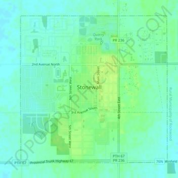
Naam: Topografische kaart Stonewall, hoogte, reliëf.
Locatie: Stonewall, Division No. 14, Manitoba, R0C 2Z0, Canada (50.12275 -97.34503 50.14507 -97.31026)
Gemiddelde hoogte: 251 m
Minimale hoogte: 245 m
Maximale hoogte: 259 m
Andere topografische kaarten
Klik op een kaart om zijn topografie, zijn hoogte en zijn reliëf te bekijken.
Pinawa
Canada > Manitoba > Division No. 1 > Local Government District of Pinawa
Gemiddelde hoogte: 277 m
Franklin
Canada > Manitoba > Division No. 15 > Rural Municipality of Rosedale
Gemiddelde hoogte: 487 m
Arden
Canada > Manitoba > Division No. 8 > Municipality of Glenella – Lansdowne
Gemiddelde hoogte: 327 m
Oak Bluff
Canada > Manitoba > Division No. 10 > Rural Municipality of Macdonald
Gemiddelde hoogte: 238 m
Sunset Beach
Canada > Manitoba > Division No. 13 > Rural Municipality of St. Clements
Gemiddelde hoogte: 223 m
Turtle Mountain Provincial Park
Canada > Manitoba > Municipality of Boissevain-Morton
Gemiddelde hoogte: 662 m
Silverton
Canada > Manitoba > Division No. 16 > Rural Municipality of Riding Mountain West
Gemiddelde hoogte: 575 m
Garson
Canada > Manitoba > Division No. 12 > Rural Municipality of Brokenhead
Gemiddelde hoogte: 242 m
Ile des Chenes
Canada > Manitoba > Division No. 2 > Rural Municipality of Ritchot
Gemiddelde hoogte: 236 m
Lenore
Canada > Manitoba > Division No. 6 > Rural Municipality of Wallace – Woodworth
Gemiddelde hoogte: 460 m
Oak Lake Beach
Canada > Manitoba > Division No. 6 > Rural Municipality of Sifton
Gemiddelde hoogte: 429 m
Butler
Canada > Manitoba > Division No. 6 > Rural Municipality of Wallace – Woodworth
Gemiddelde hoogte: 524 m
Winnipeg
Canada > Manitoba > Winnipeg > Winnipeg
Winnipeg lies at the bottom of the Red River Valley, a flood plain with an extremely flat topography. It is on the eastern edge of the Canadian Prairies in Western Canada and is known as the "Gateway to the West". Winnipeg is bordered by tallgrass prairie to the west and south and the aspen parkland to the…
Gemiddelde hoogte: 236 m