
Topografische kaart Worthington
Interactieve kaart
Klik op de kaart om de hoogte weer te geven.
Over deze kaart
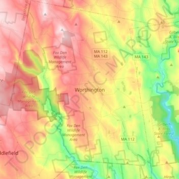
Naam: Topografische kaart Worthington, hoogte, reliëf.
Locatie: Worthington, Hampshire County, Massachusetts, United States (42.33149 -73.00908 42.44909 -72.88081)
Gemiddelde hoogte: 411 m
Minimale hoogte: 182 m
Maximale hoogte: 613 m
Andere topografische kaarten
Klik op een kaart om zijn topografie, zijn hoogte en zijn reliëf te bekijken.
Amherst
United States > Massachusetts > Hampshire County
Amherst, Hampshire County, Massachusetts, United States
Gemiddelde hoogte: 100 m
Southampton
United States > Massachusetts > Hampshire County
Southampton, Hampshire County, Massachusetts, United States
Gemiddelde hoogte: 131 m
Westbrook
United States > Massachusetts > Hampshire County > Hatfield
Westbrook, Hatfield, Hampshire County, Massachusetts, 01066, United States
Gemiddelde hoogte: 73 m
Mill River
United States > Massachusetts > Hampshire County > Northampton
Mill River, Northampton, Hampshire County, Massachusetts, United States
Gemiddelde hoogte: 103 m
Quabbin Park
United States > Massachusetts > Hampshire County > Ware
Quabbin Park, Administration Road, Ware, Hampshire County, Massachusetts, United States
Gemiddelde hoogte: 181 m
West Ware
United States > Massachusetts > Hampshire County > Ware
West Ware, Ware, Hampshire County, Massachusetts, United States
Gemiddelde hoogte: 162 m
Worthington Corners
United States > Massachusetts > Hampshire County > Worthington
Worthington Corners, Worthington, Hampshire County, Massachusetts, United States
Gemiddelde hoogte: 450 m
Belchertown
United States > Massachusetts > Hampshire County
Belchertown, Hampshire County, Massachusetts, 01007, United States
Gemiddelde hoogte: 150 m
Easthampton
United States > Massachusetts > Hampshire County
Easthampton, Hampshire County, Massachusetts, United States
Gemiddelde hoogte: 83 m
Westhampton
United States > Massachusetts > Hampshire County
Westhampton, Hampshire County, Massachusetts, 01027, United States
Gemiddelde hoogte: 260 m
Hatfield
United States > Massachusetts > Hampshire County
Hatfield, Hampshire County, Massachusetts, United States
Gemiddelde hoogte: 62 m
Florence
United States > Massachusetts > Hampshire County > Northampton
Florence, Northampton, Hampshire County, Massachusetts, 01062, United States
Gemiddelde hoogte: 78 m
Cummington
United States > Massachusetts > Hampshire County
Cummington, Hampshire County, Massachusetts, 01026, United States
Gemiddelde hoogte: 435 m
Williamsburg
United States > Massachusetts > Hampshire County
Williamsburg, Hampshire County, Massachusetts, United States
Gemiddelde hoogte: 280 m
South Hadley
United States > Massachusetts > Hampshire County > South Hadley
South Hadley, Hampshire County, Massachusetts, 01075, United States
Gemiddelde hoogte: 84 m
Cushman
United States > Massachusetts > Hampshire County > Amherst > Cushman
Cushman, Amherst, Hampshire County, Massachusetts, 01003, United States
Gemiddelde hoogte: 103 m
Piper Farm
United States > Massachusetts > Hampshire County > Belchertown
Piper Farm, Belchertown, Hampshire County, Massachusetts, United States
Gemiddelde hoogte: 150 m
Plainfield
United States > Massachusetts > Hampshire County
Plainfield, Hampshire County, Massachusetts, 01070, United States
Gemiddelde hoogte: 484 m
Granby
United States > Massachusetts > Hampshire County
Granby, Hampshire County, Massachusetts, 01033, United States
Gemiddelde hoogte: 109 m
Thermopylae
United States > Massachusetts > Hampshire County > South Hadley
Thermopylae, South Hadley, Hampshire County, Massachusetts, 01061, United States
Gemiddelde hoogte: 76 m
Northampton
United States > Massachusetts > Hampshire County
Northampton, Hampshire County, Massachusetts, United States
Gemiddelde hoogte: 71 m