
Topografische kaart Plainfield
Interactieve kaart
Klik op de kaart om de hoogte weer te geven.
Over deze kaart
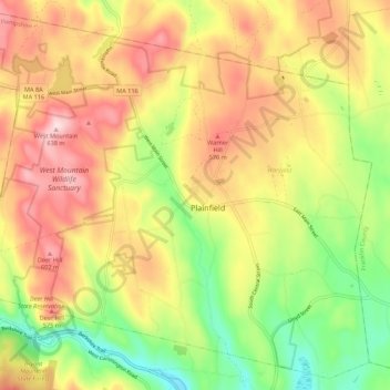
Naam: Topografische kaart Plainfield, hoogte, reliëf.
Gemiddelde hoogte: 484 m
Minimale hoogte: 323 m
Maximale hoogte: 643 m
Plainfield sits 1620′ above sea level, and the peaks of West Mountain (at 2125′) are the highest elevation in Hampshire County.
Andere topografische kaarten
Klik op een kaart om zijn topografie, zijn hoogte en zijn reliëf te bekijken.
Amherst
United States > Massachusetts > Hampshire County
Amherst, Hampshire County, Massachusetts, United States
Gemiddelde hoogte: 100 m
Southampton
United States > Massachusetts > Hampshire County
Southampton, Hampshire County, Massachusetts, United States
Gemiddelde hoogte: 131 m
Westbrook
United States > Massachusetts > Hampshire County > Hatfield
Westbrook, Hatfield, Hampshire County, Massachusetts, 01066, United States
Gemiddelde hoogte: 73 m
Mill River
United States > Massachusetts > Hampshire County > Northampton
Mill River, Northampton, Hampshire County, Massachusetts, United States
Gemiddelde hoogte: 103 m
Quabbin Park
United States > Massachusetts > Hampshire County > Ware
Quabbin Park, Administration Road, Ware, Hampshire County, Massachusetts, United States
Gemiddelde hoogte: 181 m
Worthington
United States > Massachusetts > Hampshire County
Worthington, Hampshire County, Massachusetts, United States
Gemiddelde hoogte: 411 m
West Ware
United States > Massachusetts > Hampshire County > Ware
West Ware, Ware, Hampshire County, Massachusetts, United States
Gemiddelde hoogte: 162 m
Worthington Corners
United States > Massachusetts > Hampshire County > Worthington
Worthington Corners, Worthington, Hampshire County, Massachusetts, United States
Gemiddelde hoogte: 450 m
Belchertown
United States > Massachusetts > Hampshire County
Belchertown, Hampshire County, Massachusetts, 01007, United States
Gemiddelde hoogte: 150 m
Easthampton
United States > Massachusetts > Hampshire County
Easthampton, Hampshire County, Massachusetts, United States
Gemiddelde hoogte: 83 m
Westhampton
United States > Massachusetts > Hampshire County
Westhampton, Hampshire County, Massachusetts, 01027, United States
Gemiddelde hoogte: 260 m
Hatfield
United States > Massachusetts > Hampshire County
Hatfield, Hampshire County, Massachusetts, United States
Gemiddelde hoogte: 62 m
Florence
United States > Massachusetts > Hampshire County > Northampton
Florence, Northampton, Hampshire County, Massachusetts, 01062, United States
Gemiddelde hoogte: 78 m
Cummington
United States > Massachusetts > Hampshire County
Cummington, Hampshire County, Massachusetts, 01026, United States
Gemiddelde hoogte: 435 m
Williamsburg
United States > Massachusetts > Hampshire County
Williamsburg, Hampshire County, Massachusetts, United States
Gemiddelde hoogte: 280 m
South Hadley
United States > Massachusetts > Hampshire County > South Hadley
South Hadley, Hampshire County, Massachusetts, 01075, United States
Gemiddelde hoogte: 84 m
Cushman
United States > Massachusetts > Hampshire County > Amherst > Cushman
Cushman, Amherst, Hampshire County, Massachusetts, 01003, United States
Gemiddelde hoogte: 103 m
Piper Farm
United States > Massachusetts > Hampshire County > Belchertown
Piper Farm, Belchertown, Hampshire County, Massachusetts, United States
Gemiddelde hoogte: 150 m
Granby
United States > Massachusetts > Hampshire County
Granby, Hampshire County, Massachusetts, 01033, United States
Gemiddelde hoogte: 109 m
Thermopylae
United States > Massachusetts > Hampshire County > South Hadley
Thermopylae, South Hadley, Hampshire County, Massachusetts, 01061, United States
Gemiddelde hoogte: 76 m
Northampton
United States > Massachusetts > Hampshire County
Northampton, Hampshire County, Massachusetts, United States
Gemiddelde hoogte: 71 m