
Topografische kaart Rewalsar
Interactieve kaart
Klik op de kaart om de hoogte weer te geven.
Over deze kaart
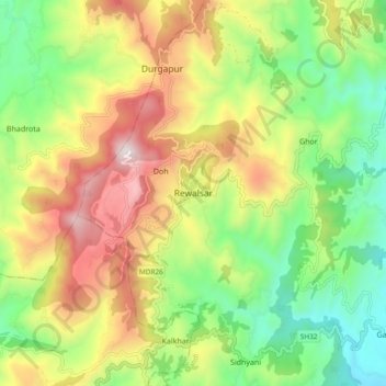
Naam: Topografische kaart Rewalsar, hoogte, reliëf.
Gemiddelde hoogte: 1.283 m
Minimale hoogte: 814 m
Maximale hoogte: 1.927 m
Rewalsar is located at an altitude of 1360 m above sea level. It is connected to Mandi by a motorable road and is about 25 km from Mandi. Lying in the Southern Himalayan belt, winters in Rewalsar can be freezing, while summers are generally pleasant.
Andere topografische kaarten
Klik op een kaart om zijn topografie, zijn hoogte en zijn reliëf te bekijken.
Mandi
India > Himachal Pradesh > Mandi
Mandi, Mandi District, Himachal Pradesh, 175001, India
Gemiddelde hoogte: 1.273 m
Nerchowk
India > Himachal Pradesh > Mandi
Nerchowk, Mandi, Mandi District, Himachal Pradesh, 175008, India
Gemiddelde hoogte: 843 m
Kamand
India > Himachal Pradesh > Mandi
Kamand, Mandi, Himachal Pradesh, 175075, India
Gemiddelde hoogte: 1.259 m
Beas River
India > Himachal Pradesh > Mandi > Pandoh
Beas River, Pandoh, Mandi, Himachal Pradesh, 175124, India
Gemiddelde hoogte: 962 m