Geolokaliseren

Topografische kaart Mandi

Interactieve kaart

Klik op de kaart om de hoogte weer te geven.

Over deze kaart

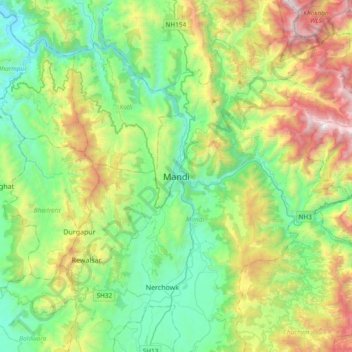
Naam: Topografische kaart Mandi, hoogte, reliëf.

Locatie: Mandi, Mandi District, Himachal Pradesh, 175001, India (31.54845 76.76938 31.86845 77.08938)

Gemiddelde hoogte: 1.273 m

Minimale hoogte: 595 m

Maximale hoogte: 2.851 m

Andere topografische kaarten

Klik op een kaart om zijn topografie, zijn hoogte en zijn reliëf te bekijken.

Nerchowk

India > Himachal Pradesh > Mandi

Nerchowk, Mandi, Mandi District, Himachal Pradesh, 175008, India

Gemiddelde hoogte: 843 m

Kamand

India > Himachal Pradesh > Mandi

Kamand, Mandi, Himachal Pradesh, 175075, India

Gemiddelde hoogte: 1.259 m

Beas River

India > Himachal Pradesh > Mandi > Pandoh

Beas River, Pandoh, Mandi, Himachal Pradesh, 175124, India

Gemiddelde hoogte: 962 m

Rewalsar

India > Himachal Pradesh > Mandi

Rewalsar, Mandi, Mandi District, Himachal Pradesh, 175023, India

Gemiddelde hoogte: 1.283 m