
Doe een donatie
Rust jezelf uit voor je volgende avontuur:
Als Amazon-partner verdient deze site een commissie op in aanmerking komende aankopen, zonder extra kosten voor jou.
Topografische kaart Oracle
Klik op de kaart om de hoogte weer te geven.
Doe een donatie
Rust jezelf uit voor je volgende avontuur:
Als Amazon-partner verdient deze site een commissie op in aanmerking komende aankopen, zonder extra kosten voor jou.
Oracle
Oracle has a cold semi-arid climate at an altitude of 4,500 feet (1,400 m). The record high temperature for Oracle was 109 °F (43 °C) recorded in July 1995. The record low temperature was 6 °F (−14 °C) recorded in December 1990. In January, the average high temperature is 56.7 °F (14 °C) with a low of 34.5 °F (1 °C). In July, the average high temperature is 92.4 °F (34 °C) with a low of 67.2 °F (20 °C). Annual precipitation is 18.59 inches (472 mm). Rainfall increases during July and August, due to the monsoon effect.
Doe een donatie
Rust jezelf uit voor je volgende avontuur:
Als Amazon-partner verdient deze site een commissie op in aanmerking komende aankopen, zonder extra kosten voor jou.
Over deze kaart
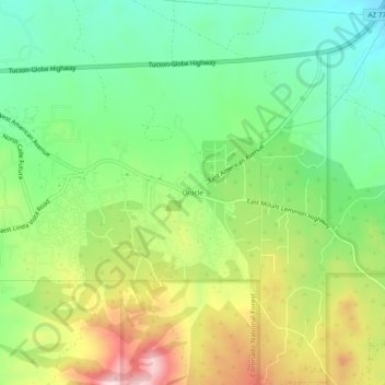
Naam: Topografische kaart Oracle, hoogte, reliëf.
Locatie: Oracle, Pinal County, Arizona, 82623, United States (32.58997 -110.78518 32.62997 -110.74518)
Gemiddelde hoogte: 1.380 m
Minimale hoogte: 1.255 m
Maximale hoogte: 1.578 m
Doe een donatie
Rust jezelf uit voor je volgende avontuur:
Als Amazon-partner verdient deze site een commissie op in aanmerking komende aankopen, zonder extra kosten voor jou.
Andere topografische kaarten
Klik op een kaart om zijn topografie, zijn hoogte en zijn reliëf te bekijken.
Superior
United States > Arizona > Pinal County
Superior has a hot semi-arid climate. In January, the average high temperature is 61 °F (16 °C) with a low of 43 °F (6 °C). In July, the average high temperature is 98 °F (37 °C) with a low of 76 °F (24 °C). Annual precipitation is just over 18 inches, but is higher at greater altitudes. Despite its…
Gemiddelde hoogte: 959 m
Arizona City
United States > Arizona > Pinal County > Arizona City
Arizona City itself is mostly flat, lying in the Santa Cruz Valley in the center of three low mountain ranges; the Sawtooth Mountains to the south, the Picacho Mountains to the east, and the Casa Grande Mountains to the north. Picacho Peak, a prominent peak with a summit elevation of 3,374 feet (1,028 m), is…
Gemiddelde hoogte: 459 m
Doe een donatie
Rust jezelf uit voor je volgende avontuur:
Als Amazon-partner verdient deze site een commissie op in aanmerking komende aankopen, zonder extra kosten voor jou.
Kearny
United States > Arizona > Pinal County
Kearny Airport is a general aviation airport located in the southern section of the town. In 2003 it received the Arizona Department of Transportation's Airport of the Year award. The airport has a single asphalt runway, 3,400 feet (1,000 m) in length and 60 feet (18 m) in width, with a field elevation of…
Gemiddelde hoogte: 578 m
Doe een donatie
Rust jezelf uit voor je volgende avontuur:
Als Amazon-partner verdient deze site een commissie op in aanmerking komende aankopen, zonder extra kosten voor jou.
Maricopa
United States > Arizona > Pinal County
The topography in Maricopa is flat, with several mountain ranges 10 to 20 miles away. The elevation of Maricopa is 1190 feet.
Gemiddelde hoogte: 369 m
Doe een donatie
Rust jezelf uit voor je volgende avontuur:
Als Amazon-partner verdient deze site een commissie op in aanmerking komende aankopen, zonder extra kosten voor jou.
Queen Valley
United States > Arizona > Pinal County
Queen Valley is located at 33°17′42″N 111°17′52″W / 33.29500°N 111.29778°W / 33.29500; -111.29778, at an elevation of 2000 feet along the south side of the west flowing Queen Creek. The Tonto National Forest boundary and Comet Peak (2681 ft.) lie 1.5 miles to the east. The dam for the…
Gemiddelde hoogte: 633 m
Doe een donatie
Rust jezelf uit voor je volgende avontuur:
Als Amazon-partner verdient deze site een commissie op in aanmerking komende aankopen, zonder extra kosten voor jou.
Arizona City
United States > Arizona > Pinal County > Arizona City
Arizona City itself is mostly flat, lying in the Santa Cruz Valley in the center of three low mountain ranges; the Sawtooth Mountains to the south, the Picacho Mountains to the east, and the Casa Grande Mountains to the north. Picacho Peak, a prominent peak with a summit elevation of 3,374 feet (1,028 m), is…
Gemiddelde hoogte: 459 m
Doe een donatie
Rust jezelf uit voor je volgende avontuur:
Als Amazon-partner verdient deze site een commissie op in aanmerking komende aankopen, zonder extra kosten voor jou.
Superior
United States > Arizona > Pinal County
Superior has a hot semi-arid climate. In January, the average high temperature is 61 °F (16 °C) with a low of 43 °F (6 °C). In July, the average high temperature is 98 °F (37 °C) with a low of 76 °F (24 °C). Annual precipitation is just over 18 inches, but is higher at greater altitudes. Despite its…
Gemiddelde hoogte: 959 m
Maricopa
United States > Arizona > Pinal County
The topography in Maricopa is flat, with several mountain ranges 10 to 20 miles away. The elevation of Maricopa is 1190 feet.
Gemiddelde hoogte: 369 m
Doe een donatie
Rust jezelf uit voor je volgende avontuur:
Als Amazon-partner verdient deze site een commissie op in aanmerking komende aankopen, zonder extra kosten voor jou.