
Doe een donatie
Rust jezelf uit voor je volgende avontuur:
Als Amazon-partner verdient deze site een commissie op in aanmerking komende aankopen, zonder extra kosten voor jou.
Topografische kaart Florence
Klik op de kaart om de hoogte weer te geven.
Doe een donatie
Rust jezelf uit voor je volgende avontuur:
Als Amazon-partner verdient deze site een commissie op in aanmerking komende aankopen, zonder extra kosten voor jou.
Over deze kaart
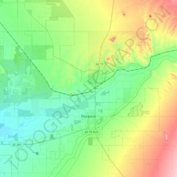
Naam: Topografische kaart Florence, hoogte, reliëf.
Locatie: Florence, Pinal County, Arizona, United States (32.98666 -111.51639 33.13299 -111.30103)
Gemiddelde hoogte: 484 m
Minimale hoogte: 426 m
Maximale hoogte: 597 m
Doe een donatie
Rust jezelf uit voor je volgende avontuur:
Als Amazon-partner verdient deze site een commissie op in aanmerking komende aankopen, zonder extra kosten voor jou.
Andere topografische kaarten
Klik op een kaart om zijn topografie, zijn hoogte en zijn reliëf te bekijken.
Arizona City
United States > Arizona > Pinal County > Arizona City
Arizona City itself is mostly flat, lying in the Santa Cruz Valley in the center of three low mountain ranges; the Sawtooth Mountains to the south, the Picacho Mountains to the east, and the Casa Grande Mountains to the north. Picacho Peak, a prominent peak with a summit elevation of 3,374 feet (1,028 m), is…
Gemiddelde hoogte: 459 m
Doe een donatie
Rust jezelf uit voor je volgende avontuur:
Als Amazon-partner verdient deze site een commissie op in aanmerking komende aankopen, zonder extra kosten voor jou.
Oracle
United States > Arizona > Pinal County
Oracle has a cold semi-arid climate at an altitude of 4,500 feet (1,400 m). The record high temperature for Oracle was 109 °F (43 °C) recorded in July 1995. The record low temperature was 6 °F (−14 °C) recorded in December 1990. In January, the average high temperature is 56.7 °F (14 °C) with a low of…
Gemiddelde hoogte: 1.380 m
Doe een donatie
Rust jezelf uit voor je volgende avontuur:
Als Amazon-partner verdient deze site een commissie op in aanmerking komende aankopen, zonder extra kosten voor jou.
Doe een donatie
Rust jezelf uit voor je volgende avontuur:
Als Amazon-partner verdient deze site een commissie op in aanmerking komende aankopen, zonder extra kosten voor jou.
Queen Valley
United States > Arizona > Pinal County
Queen Valley is located at 33°17′42″N 111°17′52″W / 33.29500°N 111.29778°W / 33.29500; -111.29778, at an elevation of 2000 feet along the south side of the west flowing Queen Creek. The Tonto National Forest boundary and Comet Peak (2681 ft.) lie 1.5 miles to the east. The dam for the…
Gemiddelde hoogte: 633 m
Doe een donatie
Rust jezelf uit voor je volgende avontuur:
Als Amazon-partner verdient deze site een commissie op in aanmerking komende aankopen, zonder extra kosten voor jou.
Arizona City
United States > Arizona > Pinal County > Arizona City
Arizona City itself is mostly flat, lying in the Santa Cruz Valley in the center of three low mountain ranges; the Sawtooth Mountains to the south, the Picacho Mountains to the east, and the Casa Grande Mountains to the north. Picacho Peak, a prominent peak with a summit elevation of 3,374 feet (1,028 m), is…
Gemiddelde hoogte: 459 m
Doe een donatie
Rust jezelf uit voor je volgende avontuur:
Als Amazon-partner verdient deze site een commissie op in aanmerking komende aankopen, zonder extra kosten voor jou.
Oracle
United States > Arizona > Pinal County
At an altitude of 4,500 feet (1,400 m), Oracle has a Mediterranean climate (Köppen Csa), somewhat similar to Prescott further northwestward. Unlike most climates of its type, only the early summer is dry, with monsoonal thunderstorms producing substantial rain in July and August. The winter season from…
Gemiddelde hoogte: 1.380 m
Heaton
United States > Arizona > Pinal County > Maricopa
Heaton is a populated place situated in Pinal County, Arizona, United States. Originally called Maricopa Station, it served as a stop on the railroad line, where passengers transferred to stagecoach. The post office at this location was simply named Maricopa. During a land boom in the late 1880s, it was…
Gemiddelde hoogte: 366 m