
Topografische kaart Union City
Interactieve kaart
Klik op de kaart om de hoogte weer te geven.
Over deze kaart
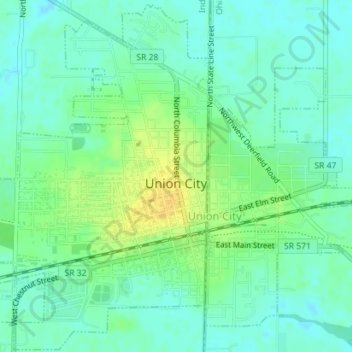
Naam: Topografische kaart Union City, hoogte, reliëf.
Locatie: Union City, Randolph County, Indiana, United States (40.18922 -84.83822 40.21577 -84.80568)
Gemiddelde hoogte: 333 m
Minimale hoogte: 324 m
Maximale hoogte: 348 m
Andere topografische kaarten
Klik op een kaart om zijn topografie, zijn hoogte en zijn reliëf te bekijken.
Parker City
United States > Indiana > Randolph County
Parker City, Randolph County, Indiana, 47368, United States
Gemiddelde hoogte: 312 m
Windsor
United States > Indiana > Randolph County
Windsor, Randolph County, Indiana, 47368, United States
Gemiddelde hoogte: 312 m
Farmland
United States > Indiana > Randolph County
Farmland, Randolph County, Indiana, United States
Gemiddelde hoogte: 318 m
Lynn
United States > Indiana > Randolph County
Lynn, Randolph County, Indiana, United States
Gemiddelde hoogte: 356 m
Modoc
United States > Indiana > Randolph County
Modoc, Randolph County, Indiana, United States
Gemiddelde hoogte: 355 m
Winchester
United States > Indiana > Randolph County
Winchester, Randolph County, Indiana, 47494, United States
Gemiddelde hoogte: 335 m