Geolokaliseren

Topografische kaart Parry Sound

Klik op de kaart om de hoogte weer te geven.

Over deze kaart

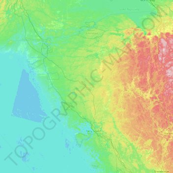
Naam: Topografische kaart Parry Sound, hoogte, reliëf.

Locatie: Parry Sound, Ontario, Canada (45.02753 -80.74553 46.30753 -79.46553)

Gemiddelde hoogte: 235 m

Minimale hoogte: 172 m

Maximale hoogte: 499 m

👉 Easily get elevation data in JSON, GeoTIFF and KML formats using Elevation API
Bedankt voor het steunen van deze site ❤️
Doe een donatie

Rust jezelf uit voor je volgende avontuur:

Als Amazon-partner verdient deze site een commissie op in aanmerking komende aankopen, zonder extra kosten voor jou.

Andere topografische kaarten

Klik op een kaart om zijn topografie, zijn hoogte en zijn reliëf te bekijken.

Ottawa

Canada > Ontario

Ottawa, the capital city of Canada, is situated on the south bank of the Ottawa River at the confluence with the Rideau River. The city's topography is characterized by gently rolling terrain with elevations ranging from approximately 44 meters (144 feet) above sea level at the Ottawa River to its highest…

Gemiddelde hoogte: 105 m

Algonquin Provincial Park

Canada > Ontario

Gemiddelde hoogte: 386 m

Thunder Bay

Canada > Ontario > Thunder Bay District

Gemiddelde hoogte: 240 m

Lake Ontario

Canada > Ontario

Lake Ontario is the easternmost of the Great Lakes and the smallest in surface area (7,340 sq mi, 18,960 km2), although it exceeds Lake Erie in volume (393 cu mi, 1,639 km3). It is the 13th largest lake in the world. When its islands are included, the lake's shoreline is 712 miles (1,146 km) long. As the last…

Gemiddelde hoogte: 214 m

Bedankt voor het steunen van deze site ❤️
Doe een donatie

Rust jezelf uit voor je volgende avontuur:

Als Amazon-partner verdient deze site een commissie op in aanmerking komende aankopen, zonder extra kosten voor jou.

Oshawa

Canada > Ontario > Durham Region

Gemiddelde hoogte: 167 m

Kitchener

Canada > Ontario > Region of Waterloo

Kitchener is located in Southwestern Ontario, in the Saint Lawrence Lowlands. This geological and climatic region has wet-climate soils and deciduous forests. Situated in the Grand River Valley, the area is generally above 300 m (1,000 ft) in elevation.

Gemiddelde hoogte: 336 m

Mississauga

Canada > Ontario > Peel Region

The shoreline of former Glacial Lake Iroquois roughly follows the Dundas Street alignment, although it is not noticeable in some places but is more prominent in others, such as the site of the former brickyard (Shoreline Dr. near Mavis Rd.), the ancient shoreline promenteau affords a clear view of downtown…

Gemiddelde hoogte: 151 m

Oakville

Canada > Ontario > Halton Region

Gemiddelde hoogte: 104 m

Bedankt voor het steunen van deze site ❤️
Doe een donatie

Rust jezelf uit voor je volgende avontuur:

Als Amazon-partner verdient deze site een commissie op in aanmerking komende aankopen, zonder extra kosten voor jou.

Barrie

Canada > Ontario > Barrie

Gemiddelde hoogte: 248 m

Essex County

Canada > Ontario

Gemiddelde hoogte: 178 m

Toronto

Canada > Ontario

Despite its deep ravines, Toronto is not remarkably hilly, but its elevation does increase steadily away from the lake. Elevation differences range from 76.5 metres (251 ft) above sea level at the Lake Ontario shore to 209 m (686 ft) ASL near the York University grounds in the city's north end at the…

Gemiddelde hoogte: 139 m

Southwestern Ontario

Canada > Ontario

Gemiddelde hoogte: 235 m

Northwestern Ontario

Canada > Ontario

Gemiddelde hoogte: 221 m

Burlington

Canada > Ontario > Halton Region

Gemiddelde hoogte: 141 m

Brampton

Canada > Ontario > Peel Region

Gemiddelde hoogte: 223 m

Eastern Ontario

Canada > Ontario

Along the extreme western edge of Eastern Ontario is a continuation of the Laurentian Highlands, known as the Opeongo Hills, and they contain some of the highest elevations in Southern Ontario. They stretch into the northern portions of Central Ontario, near Algonquin Provincial Park.

Gemiddelde hoogte: 243 m

Bedankt voor het steunen van deze site ❤️
Doe een donatie

Rust jezelf uit voor je volgende avontuur:

Als Amazon-partner verdient deze site een commissie op in aanmerking komende aankopen, zonder extra kosten voor jou.

Wilmot

Canada > Ontario > Region of Waterloo

Gemiddelde hoogte: 349 m

Ajax

Canada > Ontario > Durham Region

Gemiddelde hoogte: 101 m

Simcoe County

Canada > Ontario

The road network in Simcoe County is based on a grid pattern, with most roads running north–south or east–west. The topography of the land has permitted roads to be set in predominantly straight lines.

Gemiddelde hoogte: 265 m

Sarnia

Canada > Ontario > Lambton County

Sarnia is located on the eastern shore of Lake Huron at its extreme southern point, where it flows into the St. Clair River. Most of the surrounding area is flat, and the elevation ranges from 169 metres (554 ft) and 281 metres (922 ft) above sea level. The soil mostly comprises clay. Despite this high…

Gemiddelde hoogte: 186 m

Grand River

Canada > Ontario

Gemiddelde hoogte: 300 m

Wellington County

Canada > Ontario

Gemiddelde hoogte: 395 m

Brockville

Canada > Ontario

Gemiddelde hoogte: 98 m

Centennial Park

Canada > Ontario > Toronto

Gemiddelde hoogte: 151 m

Bedankt voor het steunen van deze site ❤️
Doe een donatie

Rust jezelf uit voor je volgende avontuur:

Als Amazon-partner verdient deze site een commissie op in aanmerking komende aankopen, zonder extra kosten voor jou.

Thornhill

Canada > Ontario > York Region > Vaughan

Gemiddelde hoogte: 206 m

Trout Lake

Canada > Ontario > Nipissing District > North Bay

Gemiddelde hoogte: 252 m

Waterloo

Canada > Ontario > Region of Waterloo

Gemiddelde hoogte: 341 m

Region of Waterloo

Canada > Ontario

Gemiddelde hoogte: 348 m

Bedankt voor het steunen van deze site ❤️
Doe een donatie

Rust jezelf uit voor je volgende avontuur:

Als Amazon-partner verdient deze site een commissie op in aanmerking komende aankopen, zonder extra kosten voor jou.

Gananoque

Canada > Ontario

Gemiddelde hoogte: 84 m

Thunder Bay District

Canada > Ontario

Gemiddelde hoogte: 321 m

Durham Region

Canada > Ontario

Gemiddelde hoogte: 235 m

Grey County

Canada > Ontario

Gemiddelde hoogte: 288 m

Bedankt voor het steunen van deze site ❤️
Doe een donatie

Rust jezelf uit voor je volgende avontuur:

Als Amazon-partner verdient deze site een commissie op in aanmerking komende aankopen, zonder extra kosten voor jou.

Cornwall

Canada > Ontario

Gemiddelde hoogte: 60 m

Barrie

Canada > Ontario

On September 7, 1977, a private aircraft, flown by "Army" Hollingsworth, dropped altitude to 500 feet (152 m) in dense fog and struck CKVR's 1,000-foot (305 m) transmitter tower, killing all five people aboard the plane and destroying the tower and antenna. The station's 225-foot (69 m) auxiliary tower was…

Gemiddelde hoogte: 265 m

East York

Canada > Ontario > Toronto

Gemiddelde hoogte: 123 m

Middlesex County

Canada > Ontario

Gemiddelde hoogte: 234 m

Markham

Canada > Ontario > York Region

Markham's average altitude is at 200 m (660 ft) and in general consists of gently rolling hills. The city is intersected by two rivers; the Don River and Rouge River, as well as their tributaries. To the north is the Oak Ridges Moraine, which further elevates the elevation towards the north.

Gemiddelde hoogte: 216 m

Whitby

Canada > Ontario > Durham Region

Gemiddelde hoogte: 155 m

Old Toronto

Canada > Ontario > Toronto

Gemiddelde hoogte: 115 m

Parry Sound District

Canada > Ontario

Gemiddelde hoogte: 237 m

Bedankt voor het steunen van deze site ❤️
Doe een donatie

Rust jezelf uit voor je volgende avontuur:

Als Amazon-partner verdient deze site een commissie op in aanmerking komende aankopen, zonder extra kosten voor jou.

Niagara Region

Canada > Ontario

Gemiddelde hoogte: 148 m

Niagara Escarpment

Canada > Ontario > Burlington

Gemiddelde hoogte: 216 m

Peterborough

Canada > Ontario

Peterborough's topography is largely defined by land formations created by the receding Wisconsian glaciers 10,000–15,000 years ago. The South End and Downtown portions of the city sit on what was the bottom of the glacial Lake Peterborough—part of a glacial spillway created when glacial meltwaters from…

Gemiddelde hoogte: 232 m

Scarborough

Canada > Ontario > Toronto

Topographically, Scarborough is dominated by two watersheds, Highland Creek and the Rouge River. Highland Creek lies almost entirely within Scarborough and occupies approximately 70% of its total area. It occupies the western half of Scarborough, while the Rouge River flows through the eastern portion. Both of…

Gemiddelde hoogte: 138 m

Newmarket

Canada > Ontario > York Region

Newmarket's geographical coordinates are 44.05°N, 79.46°W, and its elevation above sea level is 252 m. It has an area of 38.33 km². The town is bounded on the south by Aurora, on the west by King, on the north by East Gwillimbury and on the east by Whitchurch–Stouffville.

Gemiddelde hoogte: 270 m

St. Catharines

Canada > Ontario > Niagara Region

The most defining transportation icon of St. Catharines is the Welland Canal, a ship canal that runs 43.4 kilometres (27.0 mi), passing through the city. Four of its locks are within city boundaries. The canal allows shipping vessels to traverse the 99.5-metre (326.5 ft) drop in altitude from Lake Erie to Lake…

Gemiddelde hoogte: 103 m

Sault Ste. Marie

Canada > Ontario > Algoma District

Gemiddelde hoogte: 249 m

Vaughan

Canada > Ontario > York Region

Gemiddelde hoogte: 220 m

Chatham-Kent

Canada > Ontario

Gemiddelde hoogte: 183 m

Meaford

Canada > Ontario > Grey County

Gemiddelde hoogte: 222 m

Carleton Place

Canada > Ontario > Lanark County

Gemiddelde hoogte: 137 m

Hanover

Canada > Ontario > Grey County

Gemiddelde hoogte: 278 m

Deep River

Canada > Ontario > Renfrew County

John Bland, an architecture professor at McGill University, developed the town's first master plan in 1944. Bland located the town between the existing Highway 17 and the Ottawa River. He designed a system of streets which generally followed the contours of the area's topography. Residential neighborhoods…

Gemiddelde hoogte: 169 m

Frontenac County

Canada > Ontario

Gemiddelde hoogte: 169 m

Algoma District

Canada > Ontario

Gemiddelde hoogte: 305 m

Speed River

Canada > Ontario > Guelph/Eramosa

Gemiddelde hoogte: 352 m

Manitoulin Island

Canada > Ontario > Manitoulin District

Gemiddelde hoogte: 194 m

Bonnechere River

Canada > Ontario

Gemiddelde hoogte: 272 m

Guelph

Canada > Ontario

This region of Ontario has cold winters and warm, humid summers, falling into the Köppen climate classification Dfb zone (humid continental), with moderately high rainfall and snowfall. It is generally a couple of degrees cooler than lower elevation regions on the Great Lakes shorelines, especially so in…

Gemiddelde hoogte: 335 m

Prince Edward County

Canada > Ontario

Gemiddelde hoogte: 96 m

Georgian Bluffs

Canada > Ontario > Grey County

Gemiddelde hoogte: 228 m

Windsor

Canada > Ontario

Gemiddelde hoogte: 183 m

Dunlop Lake

Canada > Ontario > Elliot Lake

Gemiddelde hoogte: 379 m

Georgian Bay

Canada > Ontario

Gemiddelde hoogte: 198 m

Pigeon Lake

Canada > Ontario > Peterborough County > Trent Lakes

Gemiddelde hoogte: 264 m

Kanata South

Canada > Ontario > Ottawa

Gemiddelde hoogte: 106 m

Bedankt voor het steunen van deze site ❤️
Doe een donatie

Rust jezelf uit voor je volgende avontuur:

Als Amazon-partner verdient deze site een commissie op in aanmerking komende aankopen, zonder extra kosten voor jou.

Bay of Quinte

Canada > Ontario > Prince Edward County

Gemiddelde hoogte: 99 m

Corry Lake

Canada > Ontario

Gemiddelde hoogte: 177 m

Smooth Rock Falls

Canada > Ontario > Cochrane District

Gemiddelde hoogte: 248 m

Norway Lake

Canada > Ontario > Renfrew County > Greater Madawaska

Gemiddelde hoogte: 169 m

Centre Wellington

Canada > Ontario > Wellington County

Gemiddelde hoogte: 419 m

Central Ontario

Canada > Ontario

Along the northern edge of Central Ontario, are some of the highest elevations in Southern Ontario. These highlands are known as the Opeongo Hills, and they stretch into portions of Eastern Ontario as well.

Gemiddelde hoogte: 255 m

Otty Lake

Canada > Ontario > Lanark County > Tay Valley

Gemiddelde hoogte: 139 m

Greater Sudbury

Canada > Ontario > Sudbury District

Gemiddelde hoogte: 305 m

Haldimand County

Canada > Ontario

Gemiddelde hoogte: 190 m

Niagara Falls

Canada > Ontario > Niagara Region

Gemiddelde hoogte: 179 m

North Bay

Canada > Ontario > Nipissing District

The climate in North Bay is common to most places in Northern Ontario. North Bay tends to be a less humid climate than that found in Southern Ontario due somewhat to the distance from the Great Lakes and less warm than some other locations in Northern Ontario due to cooling from Lake Nipissing. On May 31,…

Gemiddelde hoogte: 266 m

Pembroke

Canada > Ontario

Gemiddelde hoogte: 128 m

York Region

Canada > Ontario

Gemiddelde hoogte: 243 m

Lambton

Canada > Ontario

Gemiddelde hoogte: 188 m

Toronto

Canada > Ontario

Despite its deep ravines, Toronto is not remarkably hilly, but its elevation does increase steadily away from the lake. Elevation differences range from 76.5 metres (251 ft) above sea level at the Lake Ontario shore to 209 m (686 ft) above sea level near the York University grounds in the city's north end at…

Gemiddelde hoogte: 139 m

Wasaga Beach

Canada > Ontario > Simcoe County

The Town of Wasaga Beach covers an area of 61.13 square kilometres (23.60 sq mi) comprised predominantly of sand and loamy sand that exhibit excessive to good drainage and irregular to moderately sloping topography. The poor soil quality makes it difficult to sustain lush lawns in the town. The Canada Land…

Gemiddelde hoogte: 190 m

Hamilton

Canada > Ontario

The airport's open, rural location and higher altitude results in lower temperatures, generally windier conditions, and higher snowfall amounts than lower, built-up areas of the city. The highest temperature ever recorded in Hamilton was 41.1 °C (106 °F) on July 14, 1868. The coldest temperature ever…

Gemiddelde hoogte: 187 m

Renfrew County

Canada > Ontario

Gemiddelde hoogte: 283 m

Bedankt voor het steunen van deze site ❤️
Doe een donatie

Rust jezelf uit voor je volgende avontuur:

Als Amazon-partner verdient deze site een commissie op in aanmerking komende aankopen, zonder extra kosten voor jou.

Rainy River District

Canada > Ontario

Gemiddelde hoogte: 406 m

Hastings County

Canada > Ontario

Gemiddelde hoogte: 288 m

Lambton County

Canada > Ontario

Gemiddelde hoogte: 200 m

Lanark County

Canada > Ontario

Gemiddelde hoogte: 167 m

Elgin County

Canada > Ontario

Gemiddelde hoogte: 212 m

Niagara River

Canada > Ontario

Gemiddelde hoogte: 160 m

Haliburton County

Canada > Ontario

Gemiddelde hoogte: 392 m

Lake Nipigon

Canada > Ontario

Gemiddelde hoogte: 307 m

Rust jezelf uit voor je volgende avontuur:

📸Verrekijkers - Spot wildlife en bestudeer het landschap van ver
🗺️Fysieke Kaarten België - De perfecte aanvulling op digitale topografie
🍹Thermosflessen - Warme koffie of thee op de koude toppen
🧭Expeditie Uitrusting - Voor veeleisende outdoor avonturen
🧘Reiskussens - Rust uit tijdens een lange pauze

Als Amazon-partner verdient deze site een commissie op in aanmerking komende aankopen, zonder extra kosten voor jou.