
Doe een donatie
Rust jezelf uit voor je volgende avontuur:
Als Amazon-partner verdient deze site een commissie op in aanmerking komende aankopen, zonder extra kosten voor jou.
Topografische kaart The Arboretum
Klik op de kaart om de hoogte weer te geven.
Doe een donatie
Rust jezelf uit voor je volgende avontuur:
Als Amazon-partner verdient deze site een commissie op in aanmerking komende aankopen, zonder extra kosten voor jou.
The Arboretum
Victoria Woods is an old-growth hardwood forest made up of sugar maple, white ash, black cherry and beech. Varied topography in this area, which includes a pond, allows for a wide variety of woodland plants to grow here. Spring is an especially nice time to visit Victoria Woods to see many of these spring ephemeral plants blooming. High moisture content in this woodland's soils make it unsuitable for agriculture, which is a reason why its trees have never been cut.
Doe een donatie
Rust jezelf uit voor je volgende avontuur:
Als Amazon-partner verdient deze site een commissie op in aanmerking komende aankopen, zonder extra kosten voor jou.
Over deze kaart
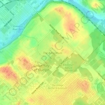
Naam: Topografische kaart The Arboretum, hoogte, reliëf.
Locatie: The Arboretum, Guelph, Ontario, Canada (43.53299 -80.22264 43.54518 -80.20741)
Gemiddelde hoogte: 332 m
Minimale hoogte: 308 m
Maximale hoogte: 352 m
Doe een donatie
Rust jezelf uit voor je volgende avontuur:
Als Amazon-partner verdient deze site een commissie op in aanmerking komende aankopen, zonder extra kosten voor jou.
Andere topografische kaarten
Klik op een kaart om zijn topografie, zijn hoogte en zijn reliëf te bekijken.
Guelph
This region of Ontario has cold winters and warm, humid summers, falling into the Köppen climate classification Dfb zone, with moderately high rainfall and snowfall. It is generally a couple of degrees cooler than lower elevation regions on the Great Lakes shorelines, especially so in winter, the exception…
Gemiddelde hoogte: 344 m