
Topografische kaart Central Manitoulin
Interactieve kaart
Klik op de kaart om de hoogte weer te geven.
Over deze kaart
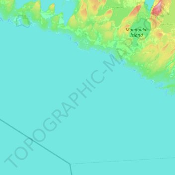
Naam: Topografische kaart Central Manitoulin, hoogte, reliëf.
Locatie: Central Manitoulin, Manitoulin District, Ontario, Canada (45.50016 -82.42905 45.82339 -81.96235)
Gemiddelde hoogte: 196 m
Minimale hoogte: 172 m
Maximale hoogte: 314 m
Andere topografische kaarten
Klik op een kaart om zijn topografie, zijn hoogte en zijn reliëf te bekijken.
Carter Bay
Canada > Ontario > Central Manitoulin
Carter Bay, Central Manitoulin, Manitoulin District, Northeastern Ontario, Ontario, Canada
Gemiddelde hoogte: 179 m