
Doe een donatie
Rust jezelf uit voor je volgende avontuur:
Als Amazon-partner verdient deze site een commissie op in aanmerking komende aankopen, zonder extra kosten voor jou.
Topografische kaart Box Canyon
Klik op de kaart om de hoogte weer te geven.
Doe een donatie
Rust jezelf uit voor je volgende avontuur:
Als Amazon-partner verdient deze site een commissie op in aanmerking komende aankopen, zonder extra kosten voor jou.
Over deze kaart
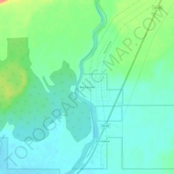
Naam: Topografische kaart Box Canyon, hoogte, reliëf.
Locatie: Box Canyon, Fremont County, Idaho, United States (44.35721 -111.42534 44.39721 -111.38534)
Gemiddelde hoogte: 1.891 m
Minimale hoogte: 1.871 m
Maximale hoogte: 1.948 m
Doe een donatie
Rust jezelf uit voor je volgende avontuur:
Als Amazon-partner verdient deze site een commissie op in aanmerking komende aankopen, zonder extra kosten voor jou.
Andere topografische kaarten
Klik op een kaart om zijn topografie, zijn hoogte en zijn reliëf te bekijken.
Island Park
United States > Idaho > Fremont County
Island Park is located at 44°29′59″N 111°20′19″W / 44.49972°N 111.33861°W / 44.49972; -111.33861 (44.4996, −111.3387), at an elevation of 6,293 feet (1,918 m) above sea level, making it the highest city in Idaho.
Gemiddelde hoogte: 2.113 m
Ashton
United States > Idaho > Fremont County
Seed potatoes Ashton was first and foremost a farming community, as the soil of the area is rich and the water is plentiful. Shortly after the first settlers arrived in the 1890s, several canals were developed to divert water from streams running off the Yellowstone Plateau and Teton Range. Some farmland,…
Gemiddelde hoogte: 1.601 m
Newdale
United States > Idaho > Fremont County
Newdale is the nearest city to the Teton Dam, which failed on June 5, 1976. Newdale did not receive any flooding or damage, due to its elevation and position relative to the dam.
Gemiddelde hoogte: 1.550 m
Doe een donatie
Rust jezelf uit voor je volgende avontuur:
Als Amazon-partner verdient deze site een commissie op in aanmerking komende aankopen, zonder extra kosten voor jou.
Newdale
United States > Idaho > Fremont County
Newdale is the nearest city to the Teton Dam, which failed on June 5, 1976. Newdale did not receive any flooding or damage, due to its elevation and position relative to the dam.
Gemiddelde hoogte: 1.550 m
Island Park
United States > Idaho > Fremont County
Island Park is located at 44°29′59″N 111°20′19″W / 44.49972°N 111.33861°W / 44.49972; -111.33861 (44.4996, −111.3387), at an elevation of 6,293 feet (1,918 m) above sea level, making it the highest city in Idaho.
Gemiddelde hoogte: 2.113 m