
Topografische kaart Murray County
Interactieve kaart
Klik op de kaart om de hoogte weer te geven.
Over deze kaart
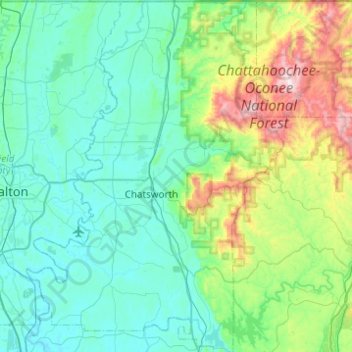
Naam: Topografische kaart Murray County, hoogte, reliëf.
Locatie: Murray County, Georgia, United States of America (34.58369 -84.94451 34.98839 -84.58493)
Gemiddelde hoogte: 381 m
Minimale hoogte: 188 m
Maximale hoogte: 1.252 m
Andere topografische kaarten
Klik op een kaart om zijn topografie, zijn hoogte en zijn reliëf te bekijken.
Athens-Clarke County Unified Government
United States of America > Georgia > Athens-Clarke County Unified Government
Athens-Clarke County Unified Government, Athens-Clarke County, Georgia, United States of America
Gemiddelde hoogte: 220 m
Barrow County
United States of America > Georgia
Barrow County, Georgia, United States of America
Gemiddelde hoogte: 261 m
Savannah
United States of America > Georgia > Savannah
Savannah, Chatham County, Georgia, United States of America
Gemiddelde hoogte: 4 m