
Topografische kaart Savannah
Interactieve kaart
Klik op de kaart om de hoogte weer te geven.
Over deze kaart
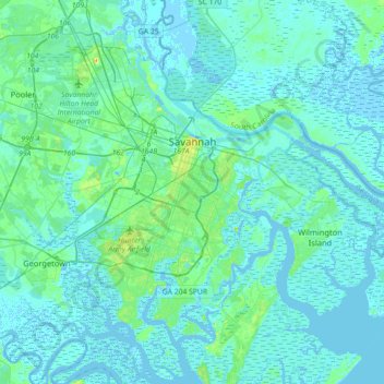
Naam: Topografische kaart Savannah, hoogte, reliëf.
Locatie: Savannah, Chatham County, Georgia, United States of America (31.88785 -81.37143 32.18966 -81.02952)
Gemiddelde hoogte: 4 m
Minimale hoogte: -5 m
Maximale hoogte: 33 m
Savannah is prone to flooding, due to abundant rainfall, an elevation at just above sea level, and the shape of the coastline, which poses a greater surge risk during hurricanes. The city currently uses five canals. In addition, several pumping stations have been built to help reduce the effects of flash flooding.