
Topografische kaart Blue Ridge Mountains
Interactieve kaart
Klik op de kaart om de hoogte weer te geven.
Over deze kaart
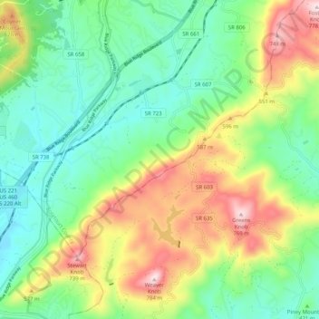
Naam: Topografische kaart Blue Ridge Mountains, hoogte, reliëf.
Gemiddelde hoogte: 460 m
Minimale hoogte: 290 m
Maximale hoogte: 774 m
Although the term "Blue Ridge" is sometimes applied exclusively to the eastern edge or front range of the Appalachian Mountains, the geological definition of the Blue Ridge province extends westward to the Ridge and Valley area, encompassing the Great Smoky Mountains, the Great Balsams, the Roans, the Blacks, and other mountain ranges. To the east, two lower elevation ranges referred to as foothills are also often included as "spurs" of the Blue Ridge: the Brushy Mountains and the South Mountains.
Andere topografische kaarten
Klik op een kaart om zijn topografie, zijn hoogte en zijn reliëf te bekijken.
Fincastle
United States > Virginia > Botetourt County
Fincastle, Botetourt County, Virginia, 24090, United States
Gemiddelde hoogte: 363 m
Troutville
United States > Virginia > Botetourt County
Troutville, Botetourt County, Virginia, United States
Gemiddelde hoogte: 458 m
Eagle Rock
United States > Virginia > Botetourt County
Eagle Rock, Botetourt County, Virginia, 24085, United States
Gemiddelde hoogte: 379 m
Daleville
United States > Virginia > Botetourt County
Daleville, Botetourt County, Virginia, 24083, United States
Gemiddelde hoogte: 410 m
Cloverdale
United States > Virginia > Botetourt County
Cloverdale, Runaway Village, Botetourt County, Virginia, United States
Gemiddelde hoogte: 401 m
Oriskany
United States > Virginia > Botetourt County
Oriskany, Botetourt County, Virginia, 24130, United States
Gemiddelde hoogte: 404 m
Glen Wilton
United States > Virginia > Botetourt County
Glen Wilton, Botetourt County, Virginia, 24438, United States
Gemiddelde hoogte: 363 m
Coyner Mountain Overlook
United States > Virginia > Botetourt County
Coyner Mountain Overlook, Botetourt County, Virginia, 25012, United States
Gemiddelde hoogte: 381 m
Daleville
United States > Virginia > Botetourt County
Daleville, Botetourt County, Virginia, 24083, United States
Gemiddelde hoogte: 412 m
Haden
United States > Virginia > Botetourt County > Haden
Haden, Botetourt County, Virginia, 24438, United States
Gemiddelde hoogte: 339 m
Buchanan
United States > Virginia > Botetourt County
Buchanan, Botetourt County, Virginia, 24066, United States
Gemiddelde hoogte: 344 m
Laymantown
United States > Virginia > Botetourt County > Laymantown
Laymantown, Botetourt County, Virginia, United States
Gemiddelde hoogte: 412 m
Blue Ridge
United States > Virginia > Botetourt County
Blue Ridge, Botetourt County, Virginia, United States
Gemiddelde hoogte: 472 m