
Topografische kaart Knossington
Klik op de kaart om de hoogte weer te geven.
Over deze kaart
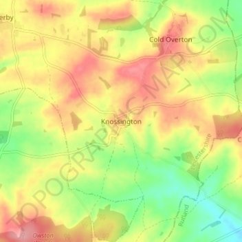
Naam: Topografische kaart Knossington, hoogte, reliëf.
Gemiddelde hoogte: 172 m
Minimale hoogte: 120 m
Maximale hoogte: 218 m
Andere topografische kaarten
Klik op een kaart om zijn topografie, zijn hoogte en zijn reliëf te bekijken.
Bottesford
United Kingdom > England > Leicestershire > Melton
Bottesford's many listed buildings include the grade I listed 13th-century Church of St Mary the Virgin. There are two scheduled monuments within the village – Fleming's Bridge and the stone cross in the Market Place. The stocks and whipping post are Grade II listed. One of the Grade II listed buildings,…
Gemiddelde hoogte: 39 m
Langham Brook
United Kingdom > England > Leicestershire > Melton > Saxby > Freeby
Gemiddelde hoogte: 94 m
Belvoir Castle
United Kingdom > England > Leicestershire > Melton > Belvoir
The traditional burial place of the Manners family was St Mary the Virgin's Church, Bottesford. Since elevation to the dukedom in 1703 most Dukes have been buried in the grounds of the mausoleum at Belvoir Castle. The mausoleum at Belvoir Castle was built by The 5th Duke of Rutland, following the death of his…
Gemiddelde hoogte: 82 m
Croxton Kerrial
United Kingdom > England > Leicestershire > Melton > Croxton Kerrial
Gemiddelde hoogte: 128 m