
Doe een donatie
Rust jezelf uit voor je volgende avontuur:
Als Amazon-partner verdient deze site een commissie op in aanmerking komende aankopen, zonder extra kosten voor jou.
Topografische kaart Belvoir Castle
Klik op de kaart om de hoogte weer te geven.
Doe een donatie
Rust jezelf uit voor je volgende avontuur:
Als Amazon-partner verdient deze site een commissie op in aanmerking komende aankopen, zonder extra kosten voor jou.
Belvoir Castle
The traditional burial place of the Manners family was St Mary the Virgin's Church, Bottesford. Since elevation to the dukedom in 1703 most Dukes have been buried in the grounds of the mausoleum at Belvoir Castle. The mausoleum at Belvoir Castle was built by The 5th Duke of Rutland, following the death of his wife, Elizabeth Howard (1780-1825), daughter of The 5th Earl of Carlisle. After its construction, most of the 18th century monuments in Belton Church were moved to the mausoleum which then became the family's main place of burial.
Doe een donatie
Rust jezelf uit voor je volgende avontuur:
Als Amazon-partner verdient deze site een commissie op in aanmerking komende aankopen, zonder extra kosten voor jou.
Over deze kaart
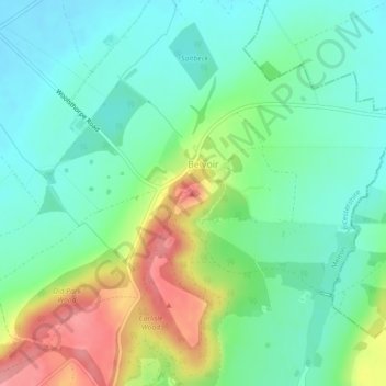
Naam: Topografische kaart Belvoir Castle, hoogte, reliëf.
Gemiddelde hoogte: 82 m
Minimale hoogte: 49 m
Maximale hoogte: 151 m
Doe een donatie
Rust jezelf uit voor je volgende avontuur:
Als Amazon-partner verdient deze site een commissie op in aanmerking komende aankopen, zonder extra kosten voor jou.