
Topografische kaart Malad
Interactieve kaart
Klik op de kaart om de hoogte weer te geven.
Over deze kaart
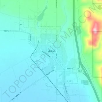
Naam: Topografische kaart Malad, hoogte, reliëf.
Locatie: Malad, Malad City, Oneida County, Idaho, United States (42.15159 -112.29080 42.23159 -112.21080)
Gemiddelde hoogte: 1.467 m
Minimale hoogte: 1.348 m
Maximale hoogte: 2.091 m
According to the United States Census Bureau, the city has a total area of 1.66 square miles (4.30 km2), all of it land. It lies on the eastern edge of Malad Valley at 4,540 feet (1384 m) in elevation.
Andere topografische kaarten
Klik op een kaart om zijn topografie, zijn hoogte en zijn reliëf te bekijken.
Cedarhill
United States > Idaho > Oneida County
Cedarhill, Oneida County, Idaho, United States
Gemiddelde hoogte: 1.651 m
Malad City
United States > Idaho > Oneida County
Malad City, Oneida County, Idaho, United States
Gemiddelde hoogte: 1.406 m