
Doe een donatie
Rust jezelf uit voor je volgende avontuur:
Als Amazon-partner verdient deze site een commissie op in aanmerking komende aankopen, zonder extra kosten voor jou.
Topografische kaart Malad City
Klik op de kaart om de hoogte weer te geven.
Doe een donatie
Rust jezelf uit voor je volgende avontuur:
Als Amazon-partner verdient deze site een commissie op in aanmerking komende aankopen, zonder extra kosten voor jou.
Malad City
According to the United States Census Bureau, the city has a total area of 1.66 square miles (4.30 km2), all of it land. It lies on the eastern edge of Malad Valley at 4,540 feet (1384 m) in elevation.
Doe een donatie
Rust jezelf uit voor je volgende avontuur:
Als Amazon-partner verdient deze site een commissie op in aanmerking komende aankopen, zonder extra kosten voor jou.
Over deze kaart
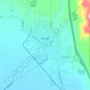
Naam: Topografische kaart Malad City, hoogte, reliëf.
Locatie: Malad City, Oneida County, Idaho, United States (42.17254 -112.26765 42.20570 -112.23513)
Gemiddelde hoogte: 1.406 m
Minimale hoogte: 1.365 m
Maximale hoogte: 1.653 m
Doe een donatie
Rust jezelf uit voor je volgende avontuur:
Als Amazon-partner verdient deze site een commissie op in aanmerking komende aankopen, zonder extra kosten voor jou.
Andere topografische kaarten
Klik op een kaart om zijn topografie, zijn hoogte en zijn reliëf te bekijken.