
Topografische kaart Farmers Branch
Interactieve kaart
Klik op de kaart om de hoogte weer te geven.
Over deze kaart
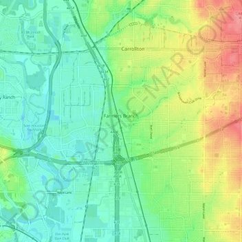
Naam: Topografische kaart Farmers Branch, hoogte, reliëf.
Locatie: Farmers Branch, Dallas County, Texas, 75234, United States (32.89559 -96.93796 32.95328 -96.82147)
Gemiddelde hoogte: 150 m
Minimale hoogte: 124 m
Maximale hoogte: 199 m
Andere topografische kaarten
Klik op een kaart om zijn topografie, zijn hoogte en zijn reliëf te bekijken.
Dallas
United States > Texas > Dallas County
Dallas, Dallas County, Texas, United States
Gemiddelde hoogte: 160 m
Irving
United States > Texas > Dallas County
Irving, Dallas County, Texas, United States
Gemiddelde hoogte: 149 m
Kenwood
United States > Texas > Dallas County > Dallas
Kenwood, Dallas, Dallas County, Texas, 75233, United States
Gemiddelde hoogte: 199 m
Cedar Hill
United States > Texas > Dallas County
Cedar Hill, Dallas County, Texas, 75104, United States
Gemiddelde hoogte: 214 m
Richardson
United States > Texas > Dallas County
Richardson, Dallas County, Texas, United States
Gemiddelde hoogte: 191 m
Lancaster
United States > Texas > Dallas County
Lancaster, Dallas County, Texas, United States
Gemiddelde hoogte: 165 m
Wilmer
United States > Texas > Dallas County
Wilmer, Dallas County, Texas, 75172, United States
Gemiddelde hoogte: 140 m
Rowlett
United States > Texas > Dallas County
Rowlett, Dallas County, Texas, United States
Gemiddelde hoogte: 147 m
Klyde Warren Park-Arts District PID
United States > Texas > Dallas County > Dallas
Klyde Warren Park-Arts District PID, Dallas, Dallas County, Texas, 75201, United States
Gemiddelde hoogte: 143 m
Balch Springs
United States > Texas > Dallas County
Balch Springs, Dallas County, Texas, United States
Gemiddelde hoogte: 147 m
Klyde Warren Park
United States > Texas > Dallas County > Dallas
Klyde Warren Park, Klyde Warren Park-Arts District PID, Dallas, Dallas County, Texas, 75201, United States
Gemiddelde hoogte: 142 m
University Park
United States > Texas > Dallas County
University Park, Dallas County, Texas, United States
Gemiddelde hoogte: 179 m
Grand Prairie
United States > Texas > Dallas County
Grand Prairie, Dallas County, Texas, United States
Gemiddelde hoogte: 181 m
Seagoville
United States > Texas > Dallas County > Seagoville
Seagoville, Dallas County, Texas, 75159, United States
Gemiddelde hoogte: 122 m
Dallas
United States > Texas > Dallas County > Dallas
Dallas, Dallas County, Texas, 75242, United States
Gemiddelde hoogte: 158 m
Irving
United States > Texas > Dallas County > Irving
Irving, Dallas County, Texas, 75061, United States
Gemiddelde hoogte: 162 m
Sunnyvale
United States > Texas > Dallas County > Sunnyvale
Sunnyvale, Dallas County, Texas, 75182, United States
Gemiddelde hoogte: 142 m
Grand Prairie
United States > Texas > Dallas County > Grand Prairie
Grand Prairie, Dallas County, Texas, 75051, United States
Gemiddelde hoogte: 170 m
Pioneer Park
United States > Texas > Dallas County > Dallas
Pioneer Park, Downtown PID, Dallas, Dallas County, Texas, United States
Gemiddelde hoogte: 135 m
Coppell
United States > Texas > Dallas County
Coppell, Dallas County, Texas, 75019, United States
Gemiddelde hoogte: 160 m
Coppell
United States > Texas > Dallas County > Coppell
Coppell, Dallas County, Texas, 75019, United States
Gemiddelde hoogte: 160 m
Mesquite
United States > Texas > Dallas County
Mesquite, Dallas County, Texas, United States
Gemiddelde hoogte: 142 m