
Topografische kaart Kenwood
Interactieve kaart
Klik op de kaart om de hoogte weer te geven.
Over deze kaart
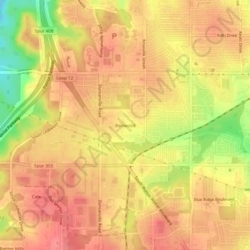
Naam: Topografische kaart Kenwood, hoogte, reliëf.
Locatie: Kenwood, Dallas, Dallas County, Texas, 75233, United States (32.69208 -96.92389 32.73208 -96.88389)
Gemiddelde hoogte: 199 m
Minimale hoogte: 149 m
Maximale hoogte: 222 m
Andere topografische kaarten
Klik op een kaart om zijn topografie, zijn hoogte en zijn reliëf te bekijken.
Klyde Warren Park-Arts District PID
United States > Texas > Dallas County > Dallas
Klyde Warren Park-Arts District PID, Dallas, Dallas County, Texas, 75201, United States
Gemiddelde hoogte: 143 m
Klyde Warren Park
United States > Texas > Dallas County > Dallas
Klyde Warren Park, Klyde Warren Park-Arts District PID, Dallas, Dallas County, Texas, 75201, United States
Gemiddelde hoogte: 142 m
Dallas
United States > Texas > Dallas County > Dallas
Dallas, Dallas County, Texas, 75242, United States
Gemiddelde hoogte: 158 m
Pioneer Park
United States > Texas > Dallas County > Dallas
Pioneer Park, Downtown PID, Dallas, Dallas County, Texas, United States
Gemiddelde hoogte: 135 m