
Topografische kaart Kodia
Interactieve kaart
Klik op de kaart om de hoogte weer te geven.
Over deze kaart
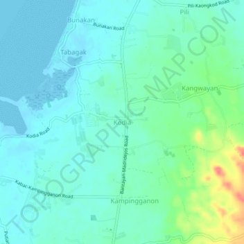
Naam: Topografische kaart Kodia, hoogte, reliëf.
Locatie: Kodia, Cebu, Central Visayas, Philippines (11.22767 123.70300 11.26767 123.74300)
Gemiddelde hoogte: 14 m
Minimale hoogte: -6 m
Maximale hoogte: 65 m
Andere topografische kaarten
Klik op een kaart om zijn topografie, zijn hoogte en zijn reliëf te bekijken.
Balidbid
Philippines > Cebu > Balidbid
Balidbid, Cebu, Central Visayas, Philippines
Gemiddelde hoogte: 9 m
Busay Falls
Philippines > Cebu > Mandaue
Busay Falls, Mandaue, Cebu, Central Visayas, 6000, Philippines
Gemiddelde hoogte: 282 m
Mactan Island
Philippines > Cebu > Lapu-Lapu
Mactan Island, Lapu-Lapu, Cebu, Central Visayas, Philippines
Gemiddelde hoogte: 3 m