
Topografische kaart The Municipal District of Baltinglass
Interactieve kaart
Klik op de kaart om de hoogte weer te geven.
Over deze kaart
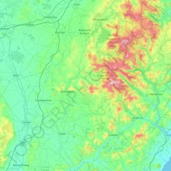
Naam: Topografische kaart The Municipal District of Baltinglass, hoogte, reliëf.
Gemiddelde hoogte: 182 m
Minimale hoogte: 0 m
Maximale hoogte: 927 m
Andere topografische kaarten
Klik op een kaart om zijn topografie, zijn hoogte en zijn reliëf te bekijken.
Little Sugar Loaf
Little Sugar Loaf, The Municipal District of Bray, County Wicklow, Leinster, A63 FX34, Irland
Gemiddelde hoogte: 131 m
Wicklow Mountains National Park
Wicklow Mountains National Park, County Wicklow, Leinster, Irland
Gemiddelde hoogte: 322 m