
Topografische kaart Little Sugar Loaf
Interactieve kaart
Klik op de kaart om de hoogte weer te geven.
Over deze kaart
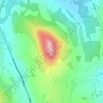
Naam: Topografische kaart Little Sugar Loaf, hoogte, reliëf.
Gemiddelde hoogte: 131 m
Minimale hoogte: 53 m
Maximale hoogte: 331 m
Andere topografische kaarten
Klik op een kaart om zijn topografie, zijn hoogte en zijn reliëf te bekijken.
Roundwood
Roundwood, historisch auch als Togher bekannt, befindet sich am Kreuzungspunkt der Regionalstraßen R755, R764 und R765. Die R755 ist die Hauptverkehrsstrecke von Dublin in das südlich gelegene Glendalough in den Wicklow Mountains. Mit einer Seehöhe von 238 m ist Roundwood eines der höchstgelegenen Dörfer…
Gemiddelde hoogte: 242 m
Wicklow Mountains National Park
Das archäologische Denkmal liegt neben dem Upper Lake. Es ist ein steinernes ein Ringfort mit einer Trockenmauer von etwa 20 m Durchmesser, die etwa einen Meter Resthöhe hat. Cahers werden regional als Cathair, Cashel oder Dun und lage-, form- bzw. materialbezogen auch als Cliff-, Coastal-, Promontory-,…
Gemiddelde hoogte: 322 m