
Topografische kaart Schwanden
Interactieve kaart
Klik op de kaart om de hoogte weer te geven.
Over deze kaart
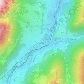
Naam: Topografische kaart Schwanden, hoogte, reliëf.
Locatie: Schwanden, Glarus Süd, Glarus, 8762, Switzerland (46.97556 9.05136 47.01556 9.09136)
Gemiddelde hoogte: 813 m
Minimale hoogte: 498 m
Maximale hoogte: 1.744 m
Schwanden is situated at an elevation of 528 m (1,732 ft) at the point of confluence of the Linth and Sernf rivers. The village is located along the roads to Elm, Linthal and Schwändi, and includes the formerly independent (until 1876) hamlet of Thon. The villages of Nidfurn and Haslen lie to south in the valley of the Linth, whilst the village of Engi lies to the east in the valley of the Sernf. To the north, the village of Mitlödi lies in the valley of the Linth, whilst Schwandi and Sool are respectively on the west and east slopes of the valley.
Andere topografische kaarten
Klik op een kaart om zijn topografie, zijn hoogte en zijn reliëf te bekijken.
Braunwald
Switzerland > Glarus > Glarus Süd
Braunwald, Glarus Süd, Glarus, 8784, Switzerland
Gemiddelde hoogte: 1.215 m
Schwander Grat
Switzerland > Glarus > Glarus Süd
Schwander Grat, Glarus Süd, Glarus, 8774, Switzerland
Gemiddelde hoogte: 2.289 m
Tödi
Switzerland > Glarus > Glarus Süd
Tödi, Glarus Süd, Glarus, Switzerland
Gemiddelde hoogte: 2.919 m
Mitlödi
Switzerland > Glarus > Glarus Süd > Mitlödi
Mitlödi, Glarus Süd, Glarus, 8756, Switzerland
Gemiddelde hoogte: 800 m