
Topografische kaart Mitlödi
Interactieve kaart
Klik op de kaart om de hoogte weer te geven.
Over deze kaart
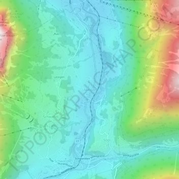
Naam: Topografische kaart Mitlödi, hoogte, reliëf.
Locatie: Mitlödi, Glarus Süd, Glarus, 8756, Switzerland (46.99147 9.05991 47.03147 9.09991)
Gemiddelde hoogte: 800 m
Minimale hoogte: 481 m
Maximale hoogte: 1.745 m
Mitlödi is located in the valley of the Linth river, on a pre-historic rock slide, at an elevation of 504 m (1,654 ft). It consists of the village of Mitlödi itself, and the separate section of Ennetlinth on the right bank of the Linth. The village of Schwanden lies upstream and to the south, whilst the town of Glarus is downstream and to the north.