
Topografische kaart Derrycastle
Interactieve kaart
Klik op de kaart om de hoogte weer te geven.
Over deze kaart
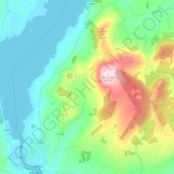
Naam: Topografische kaart Derrycastle, hoogte, reliëf.
Gemiddelde hoogte: 152 m
Minimale hoogte: 28 m
Maximale hoogte: 455 m
Andere topografische kaarten
Klik op een kaart om zijn topografie, zijn hoogte en zijn reliëf te bekijken.
The Municipal District of Nenagh
The Municipal District of Nenagh, County Tipperary, Munster, Irland
Gemiddelde hoogte: 116 m
Borrisoleigh
Irland > County Tipperary > Borrisoleigh
Borrisoleigh, The Municipal District of Thurles, County Tipperary, Munster, Irland
Gemiddelde hoogte: 128 m