
Doe een donatie
Rust jezelf uit voor je volgende avontuur:
Als Amazon-partner verdient deze site een commissie op in aanmerking komende aankopen, zonder extra kosten voor jou.
Topografische kaart Vancouver Island
Klik op de kaart om de hoogte weer te geven.
Doe een donatie
Rust jezelf uit voor je volgende avontuur:
Als Amazon-partner verdient deze site een commissie op in aanmerking komende aankopen, zonder extra kosten voor jou.
Vancouver Island
The rain shadow effect of the island's mountains, as well as the mountains of Washington's Olympic Peninsula, creates wide variation in precipitation. The west coast is considerably wetter than the east coast. Average annual precipitation ranges from 6,650 mm (262 in) at Hucuktlis Lake on the west coast (making it the wettest place in North America) to only 608 mm (23.9 in) at Victoria Gonzales, the driest recording station in the provincial capital of Victoria. Precipitation is heaviest in the autumn and winter. Snow is rare at low altitudes, but is common on the island's mountaintops in winter. Skiing is popular at Mount Washington in the mid-island, with an elevation of 1,588 m (5,210 ft).
Doe een donatie
Rust jezelf uit voor je volgende avontuur:
Als Amazon-partner verdient deze site een commissie op in aanmerking komende aankopen, zonder extra kosten voor jou.
Over deze kaart
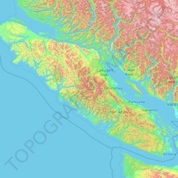
Naam: Topografische kaart Vancouver Island, hoogte, reliëf.
Locatie: Vancouver Island, British Columbia, Canada (48.30888 -128.43292 50.87683 -123.26478)
Gemiddelde hoogte: 411 m
Minimale hoogte: -3 m
Maximale hoogte: 3.169 m
Doe een donatie
Rust jezelf uit voor je volgende avontuur:
Als Amazon-partner verdient deze site een commissie op in aanmerking komende aankopen, zonder extra kosten voor jou.
Andere topografische kaarten
Klik op een kaart om zijn topografie, zijn hoogte en zijn reliëf te bekijken.
Grouse Mountain
Canada > British Columbia > Metro Vancouver Regional District
Grouse Mountain is one of the North Shore Mountains of the Pacific Ranges in the District Municipality of North Vancouver, British Columbia, Canada. With a maximum elevation of over 1,200 m (4,100 feet) at its peak, the mountain is the site of an alpine ski area, Grouse Mountain Resort, which overlooks Greater…
Gemiddelde hoogte: 968 m
Rock Creek
Canada > British Columbia > Regional District of Kootenay Boundary > Area E (Beaverdell/West Boundary)
Gemiddelde hoogte: 764 m
Doe een donatie
Rust jezelf uit voor je volgende avontuur:
Als Amazon-partner verdient deze site een commissie op in aanmerking komende aankopen, zonder extra kosten voor jou.
Mount Robson
Canada > British Columbia > Regional District of Fraser-Fort George > Area H (Robson Valley/Canoe)
The north face can be seen from Berg Lake, and reached by a 19 km (11.8 mi) hike. The lake is approximately 2 km long and lies at 1,646 m (5,400 ft) elevation. There are backcountry campgrounds at each end of the lake and a log shelter on its banks, named Hargreaves Shelter in honor of the Hargreaves family…
Gemiddelde hoogte: 3.042 m
Coast Mountains
Canada > British Columbia > Area A (Seymour Inlet/Knight Inlet)
The Coast Mountains are part of the Pacific Ring of Fire—the ring of volcanoes and associated mountains around the Pacific Ocean—and contain some of British Columbia's highest mountains. Mount Waddington is the highest mountain of the Coast Mountains and the highest that lies entirely within British…
Gemiddelde hoogte: 1.951 m
Whistler
Canada > British Columbia > Squamish-Lillooet Regional District > Whistler Resort Municipality > Whistler
Gemiddelde hoogte: 996 m
Doe een donatie
Rust jezelf uit voor je volgende avontuur:
Als Amazon-partner verdient deze site een commissie op in aanmerking komende aankopen, zonder extra kosten voor jou.
Genelle
Canada > British Columbia > Regional District of Kootenay Boundary > Area B (Lower Columbia/Old Glory)
Gemiddelde hoogte: 656 m
Knouff Lake
Canada > British Columbia > Thompson-Nicola Regional District > Area P (Rivers and the Peaks)
Gemiddelde hoogte: 1.249 m
Rocky Mountains
Canada > British Columbia > Regional District of East Kootenay > Area A (Upper Flathead/Elk Valley)
Gemiddelde hoogte: 2.159 m
Doe een donatie
Rust jezelf uit voor je volgende avontuur:
Als Amazon-partner verdient deze site een commissie op in aanmerking komende aankopen, zonder extra kosten voor jou.
Doe een donatie
Rust jezelf uit voor je volgende avontuur:
Als Amazon-partner verdient deze site een commissie op in aanmerking komende aankopen, zonder extra kosten voor jou.
Cultus Lake
Canada > British Columbia > Fraser Valley Regional District > Area H (Cultus Lake/Columbia Valley) > Cultus Lake
Gemiddelde hoogte: 191 m
Shawnigan Lake
Canada > British Columbia > Cowichan Valley Regional District > Area B (Shawnigan Lake)
Gemiddelde hoogte: 128 m
Doe een donatie
Rust jezelf uit voor je volgende avontuur:
Als Amazon-partner verdient deze site een commissie op in aanmerking komende aankopen, zonder extra kosten voor jou.
70 Mile House
Canada > British Columbia > Thompson-Nicola Regional District > Area E (Bonaparte Plateau)
Gemiddelde hoogte: 1.087 m
Burnaby
Canada > British Columbia > Metro Vancouver Regional District > Burnaby
Burnaby occupies 98.60 square kilometres (38.07 sq mi) and is located at the geographic centre of the Metro Vancouver area and home to the Metro Vancouver regional government in Metrotown. Situated between the city of Vancouver on the west and Port Moody, Coquitlam, and New Westminster on the east, Burnaby is…
Gemiddelde hoogte: 144 m
Richmond
Canada > British Columbia > Metro Vancouver Regional District > Richmond
Gemiddelde hoogte: 15 m
Doe een donatie
Rust jezelf uit voor je volgende avontuur:
Als Amazon-partner verdient deze site een commissie op in aanmerking komende aankopen, zonder extra kosten voor jou.
Armstrong
Canada > British Columbia > Regional District of North Okanagan > Armstrong > Armstrong
Gemiddelde hoogte: 494 m
Ainsworth Hot Springs
Canada > British Columbia > Regional District of Central Kootenay > Area D (Lardeau Valley/Duncan Lake)
Gemiddelde hoogte: 741 m
Japan Gulch Reservoir
Canada > British Columbia > Capital Regional District > Juan de Fuca Electoral Area
Gemiddelde hoogte: 274 m
Doe een donatie
Rust jezelf uit voor je volgende avontuur:
Als Amazon-partner verdient deze site een commissie op in aanmerking komende aankopen, zonder extra kosten voor jou.
Cherryville
Canada > British Columbia > Regional District of North Okanagan > Area E (Cherryville/East Creighton)
Gemiddelde hoogte: 643 m
Bouchie Lake
Canada > British Columbia > Cariboo Regional District > Area B (Quesnel West/Bouchie Lake)
Gemiddelde hoogte: 699 m
Doe een donatie
Rust jezelf uit voor je volgende avontuur:
Als Amazon-partner verdient deze site een commissie op in aanmerking komende aankopen, zonder extra kosten voor jou.
Doe een donatie
Rust jezelf uit voor je volgende avontuur:
Als Amazon-partner verdient deze site een commissie op in aanmerking komende aankopen, zonder extra kosten voor jou.
Pavilion
The early anglicized version of the village name was Skwailuk, meaning hoar-frost, perhaps indicating the shaded ground remaining frozen during the long winters at this elevation. The Ts'kw'aylaxw First Nation (a.k.a. the Tsk'waylacw First Nation or Tsk'weylecw First Nation), residing on the Pavilion 1 Indian…
Gemiddelde hoogte: 855 m
Doe een donatie
Rust jezelf uit voor je volgende avontuur:
Als Amazon-partner verdient deze site een commissie op in aanmerking komende aankopen, zonder extra kosten voor jou.
Queen Elizabeth Park
Canada > British Columbia > Metro Vancouver Regional District > Vancouver
Gemiddelde hoogte: 81 m
Doe een donatie
Rust jezelf uit voor je volgende avontuur:
Als Amazon-partner verdient deze site een commissie op in aanmerking komende aankopen, zonder extra kosten voor jou.
Kamloops
Canada > British Columbia > Thompson-Nicola Regional District > Kamloops
Gemiddelde hoogte: 875 m
Doe een donatie
Rust jezelf uit voor je volgende avontuur:
Als Amazon-partner verdient deze site een commissie op in aanmerking komende aankopen, zonder extra kosten voor jou.
Montney
Canada > British Columbia > Peace River Regional District > Area B (Finlay Valley/Beatton Valley)
It lies at an elevation of 700 meters (2,300 ft), along the BC Rail tracks.
Gemiddelde hoogte: 718 m
Davis Lake Recreation Site
Canada > British Columbia > Thompson-Nicola Regional District > Area N (Beautiful Nicola Valley - South)
Gemiddelde hoogte: 1.123 m
Doe een donatie
Rust jezelf uit voor je volgende avontuur:
Als Amazon-partner verdient deze site een commissie op in aanmerking komende aankopen, zonder extra kosten voor jou.
Spillimacheen
Canada > British Columbia > Regional District of East Kootenay > Area G (Forster Creek/Mount Assiniboine)
Gemiddelde hoogte: 971 m
Cooper Creek
Canada > British Columbia > Regional District of Central Kootenay > Area D (Lardeau Valley/Duncan Lake)
Gemiddelde hoogte: 1.573 m
Doe een donatie
Rust jezelf uit voor je volgende avontuur:
Als Amazon-partner verdient deze site een commissie op in aanmerking komende aankopen, zonder extra kosten voor jou.
Lac La Hache
Canada > British Columbia > Cariboo Regional District > Area G (Lac La Hache/108 Mile Ranch)
Gemiddelde hoogte: 847 m
Fort Nelson
Canada > British Columbia > Northern Rockies Regional Municipality
Gemiddelde hoogte: 405 m
Britannia Beach
Canada > British Columbia > Squamish-Lillooet Regional District > Area D (Elaho/Garibaldi)
Gemiddelde hoogte: 208 m
Fort Steele
Canada > British Columbia > Regional District of East Kootenay > Area C (Moyie/Bull River)
Gemiddelde hoogte: 797 m
Doe een donatie
Rust jezelf uit voor je volgende avontuur:
Als Amazon-partner verdient deze site een commissie op in aanmerking komende aankopen, zonder extra kosten voor jou.
Lone Butte
Canada > British Columbia > Cariboo Regional District > Area L (Lone Butte/Interlakes)
The northward advance of the Pacific Great Eastern Railway (PGE) rail head passed through Lone Butte in late April 1919. This construction camp had a large kitchen employing 25 cooks, of whom two received the Distinguished Conduct Medal and three the Military Medal during World War I. At an elevation of about…
Gemiddelde hoogte: 1.159 m
150 Mile House
Canada > British Columbia > Cariboo Regional District > Area F (Horsefly/Likely/150 Mile House)
Gemiddelde hoogte: 789 m
Ernest Lake
Canada > British Columbia > Thompson-Nicola Regional District > Area L (Grasslands)
Gemiddelde hoogte: 1.260 m
Fairmont Hot Springs
Canada > British Columbia > Regional District of East Kootenay > Area F (Columbia Lake/Windermere Lake)
Gemiddelde hoogte: 920 m
Doe een donatie
Rust jezelf uit voor je volgende avontuur:
Als Amazon-partner verdient deze site een commissie op in aanmerking komende aankopen, zonder extra kosten voor jou.
Whiteswan Lake
Canada > British Columbia > Regional District of East Kootenay > Area F (Columbia Lake/Windermere Lake)
Gemiddelde hoogte: 1.392 m
Bralorne
Canada > British Columbia > Squamish-Lillooet Regional District > Area A (Upper Bridge River Valley)
Gemiddelde hoogte: 1.255 m
Sun Peaks
Canada > British Columbia > Thompson-Nicola Regional District > Sun Peaks Mountain Resort Municipality
Gemiddelde hoogte: 1.490 m
Doe een donatie
Rust jezelf uit voor je volgende avontuur:
Als Amazon-partner verdient deze site een commissie op in aanmerking komende aankopen, zonder extra kosten voor jou.
Vancouver Island Ranges
Canada > British Columbia > Area D (Oyster Bay/Buttle Lake)
Gemiddelde hoogte: 863 m
Cultus Lake
Canada > British Columbia > Thompson-Nicola Regional District > Area J (Copper Desert Country)
Gemiddelde hoogte: 1.033 m
Saanich
Canada > British Columbia > Capital Regional District > Saanich > Saanich
Gemiddelde hoogte: 32 m
Doe een donatie
Rust jezelf uit voor je volgende avontuur:
Als Amazon-partner verdient deze site een commissie op in aanmerking komende aankopen, zonder extra kosten voor jou.
Whistler Village
Canada > British Columbia > Squamish-Lillooet Regional District > Whistler
Gemiddelde hoogte: 775 m
South Thompson River
Canada > British Columbia > Thompson-Nicola Regional District > Kamloops
Gemiddelde hoogte: 421 m
Andy Livingstone Park
Canada > British Columbia > Metro Vancouver Regional District > Vancouver
Gemiddelde hoogte: 12 m
Mount Begbie
Canada > British Columbia > Columbia-Shuswap Regional District > Area B (Shelter Bay/Mica Creek)
Gemiddelde hoogte: 2.066 m
Doe een donatie
Rust jezelf uit voor je volgende avontuur:
Als Amazon-partner verdient deze site een commissie op in aanmerking komende aankopen, zonder extra kosten voor jou.
Lac Le Jeune
Canada > British Columbia > Thompson-Nicola Regional District > Area J (Copper Desert Country)
Gemiddelde hoogte: 1.309 m
Loon Lake
Canada > British Columbia > Regional District of North Okanagan > Area D (Trinity/West Creighton)
Gemiddelde hoogte: 1.360 m
Separation Lake
Canada > British Columbia > Thompson-Nicola Regional District > Area L (Grasslands)
Gemiddelde hoogte: 914 m
Mount Strachan
Canada > British Columbia > Regional District of East Kootenay > Area A (Upper Flathead/Elk Valley)
Gemiddelde hoogte: 2.198 m
Doe een donatie
Rust jezelf uit voor je volgende avontuur:
Als Amazon-partner verdient deze site een commissie op in aanmerking komende aankopen, zonder extra kosten voor jou.
Skeena Mountains
Canada > British Columbia > Regional District of Bulkley-Nechako > Area C (Stuart Lake/Omineca Valley)
Gemiddelde hoogte: 1.339 m
Cassiar Mountains
Canada > British Columbia > Peace River Regional District > Area B (Finlay Valley/Beatton Valley)
Gemiddelde hoogte: 935 m
Mill Bay
Canada > British Columbia > Cowichan Valley Regional District > Area A (Mill Bay / Malahat)
Gemiddelde hoogte: 61 m
Doe een donatie
Rust jezelf uit voor je volgende avontuur:
Als Amazon-partner verdient deze site een commissie op in aanmerking komende aankopen, zonder extra kosten voor jou.
Woss
Canada > British Columbia > Regional District of Mount Waddington > Area D (Nimpkish Valley/Cormorant Island)
Gemiddelde hoogte: 200 m
Oyster River
Canada > British Columbia > Strathcona Regional District > Area D (Oyster Bay/Buttle Lake) > Oyster River
Gemiddelde hoogte: 24 m
Shuswap
Canada > British Columbia > Regional District of East Kootenay > Area F (Columbia Lake/Windermere Lake)
Gemiddelde hoogte: 926 m
Gabriola
Canada > British Columbia > Regional District of Nanaimo > Area B (DeCourcy/Gabriola/Mudge)
Gabriola is about 14 kilometres (9 mi) long by 4.2 kilometres (2.6 mi) wide on average with a land area of 57.6 square kilometres (22.2 sq mi). The topography varies from flat sandy beaches at sea level to forested hills rising to 160 metres (525 ft) on Stoney Ridge in the centre of the island.
Gemiddelde hoogte: 31 m
Doe een donatie
Rust jezelf uit voor je volgende avontuur:
Als Amazon-partner verdient deze site een commissie op in aanmerking komende aankopen, zonder extra kosten voor jou.
Errington
Canada > British Columbia > Regional District of Nanaimo > Area F (Alberni Highway)
Gemiddelde hoogte: 120 m
The Commons Field
Canada > British Columbia > Regional District of Central Okanagan > Kelowna
Gemiddelde hoogte: 442 m
Woodlot 0007
Canada > British Columbia > Metro Vancouver Regional District > Maple Ridge
Gemiddelde hoogte: 322 m
Agur Lake
Canada > British Columbia > Regional District of Okanagan-Similkameen > Area F (Trout Creek Valley)
Gemiddelde hoogte: 1.178 m
Doe een donatie
Rust jezelf uit voor je volgende avontuur:
Als Amazon-partner verdient deze site een commissie op in aanmerking komende aankopen, zonder extra kosten voor jou.
Faulder
Canada > British Columbia > Regional District of Okanagan-Similkameen > Area F (Trout Creek Valley)
Gemiddelde hoogte: 850 m
Crooked River
Canada > British Columbia > Regional District of Fraser-Fort George > Area G (Crooked River/Parsnip)
Gemiddelde hoogte: 749 m
Carp Lake
Canada > British Columbia > Regional District of Fraser-Fort George > Area G (Crooked River/Parsnip)
Gemiddelde hoogte: 865 m
Pine River
Canada > British Columbia > Peace River Regional District > Area E (Moberly Lake/Sukunka Valley)
Gemiddelde hoogte: 973 m
Doe een donatie
Rust jezelf uit voor je volgende avontuur:
Als Amazon-partner verdient deze site een commissie op in aanmerking komende aankopen, zonder extra kosten voor jou.
Parkland
Canada > British Columbia > Peace River Regional District > Area D (Kiskatinaw Valley)
Gemiddelde hoogte: 726 m
Walnut Park
Canada > British Columbia > Metro Vancouver Regional District > Surrey
Gemiddelde hoogte: 49 m
Mount Tabor
Canada > British Columbia > Regional District of Fraser-Fort George > Area D (Tabor Lake/Stone Creek)
Gemiddelde hoogte: 1.119 m
Doe een donatie
Rust jezelf uit voor je volgende avontuur:
Als Amazon-partner verdient deze site een commissie op in aanmerking komende aankopen, zonder extra kosten voor jou.