
Doe een donatie
Rust jezelf uit voor je volgende avontuur:
Als Amazon-partner verdient deze site een commissie op in aanmerking komende aankopen, zonder extra kosten voor jou.
Topografische kaart Lone Butte
Klik op de kaart om de hoogte weer te geven.
Doe een donatie
Rust jezelf uit voor je volgende avontuur:
Als Amazon-partner verdient deze site een commissie op in aanmerking komende aankopen, zonder extra kosten voor jou.
Lone Butte
The northward advance of the Pacific Great Eastern Railway (PGE) rail head passed through Lone Butte in late April 1919. This construction camp had a large kitchen employing 25 cooks, of whom two received the Distinguished Conduct Medal and three the Military Medal during World War I. At an elevation of about 1,140 metres (3,740 ft), the former station was the highest on the line.
Doe een donatie
Rust jezelf uit voor je volgende avontuur:
Als Amazon-partner verdient deze site een commissie op in aanmerking komende aankopen, zonder extra kosten voor jou.
Over deze kaart
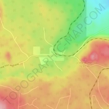
Naam: Topografische kaart Lone Butte, hoogte, reliëf.
Gemiddelde hoogte: 1.159 m
Minimale hoogte: 1.084 m
Maximale hoogte: 1.225 m
Doe een donatie
Rust jezelf uit voor je volgende avontuur:
Als Amazon-partner verdient deze site een commissie op in aanmerking komende aankopen, zonder extra kosten voor jou.
Andere topografische kaarten
Klik op een kaart om zijn topografie, zijn hoogte en zijn reliëf te bekijken.
Needa Lake
Canada > British Columbia > Cariboo Regional District > Area L (Lone Butte/Interlakes)
Gemiddelde hoogte: 1.192 m
Horse Lake
Canada > British Columbia > Cariboo Regional District > Area L (Lone Butte/Interlakes)
Gemiddelde hoogte: 1.097 m
Sheridan Lake
Canada > British Columbia > Cariboo Regional District > Area L (Lone Butte/Interlakes)
Gemiddelde hoogte: 1.127 m
Interlakes
Canada > British Columbia > Cariboo Regional District > Area L (Lone Butte/Interlakes)
Gemiddelde hoogte: 1.126 m
Doe een donatie
Rust jezelf uit voor je volgende avontuur:
Als Amazon-partner verdient deze site een commissie op in aanmerking komende aankopen, zonder extra kosten voor jou.
Bridge Lake
Canada > British Columbia > Cariboo Regional District > Area L (Lone Butte/Interlakes)
Gemiddelde hoogte: 1.158 m