
Topografische kaart Meltham
Klik op de kaart om de hoogte weer te geven.
Over deze kaart
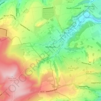
Naam: Topografische kaart Meltham, hoogte, reliëf.
Locatie: Meltham, Kirklees, West Yorkshire, England, United Kingdom (53.56447 -1.90694 53.61519 -1.81310)
Gemiddelde hoogte: 278 m
Minimale hoogte: 106 m
Maximale hoogte: 497 m
Andere topografische kaarten
Klik op een kaart om zijn topografie, zijn hoogte en zijn reliëf te bekijken.
Slaithwaite
United Kingdom > England > Kirklees
In the 1848 edition of 'A Topographical Dictionary of England', Samuel Lewis (the editor) wrote:- "the lands are in meadow and pasture, with a small portion of arable; the scenery is bold and romantic. In the quarries of the district are found vegetable fossils, especially firs and other mountain trees. The…
Gemiddelde hoogte: 241 m
Clayton West
United Kingdom > England > Kirklees
Listed as Clayton, West, the village featured in "A Topographical Dictionary of England" which was published by Samuel Lewis, London, 1848. In 1848 the village had 1440 residents and was described as being 1080 acres belonging to various owners. Mining was listed as the predominant industry, along with the…
Gemiddelde hoogte: 150 m