
Topografische kaart Cuyo
Interactieve kaart
Klik op de kaart om de hoogte weer te geven.
Over deze kaart
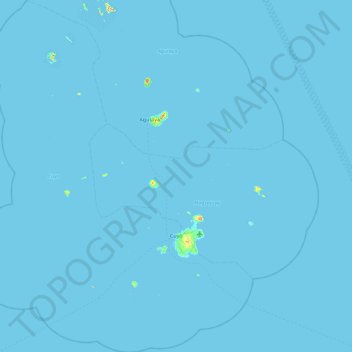
Naam: Topografische kaart Cuyo, hoogte, reliëf.
Locatie: Cuyo, Palawan, Mimaropa, 5318, Philippines (10.55859 120.47054 11.46030 121.20413)
Gemiddelde hoogte: 0 m
Minimale hoogte: -1 m
Maximale hoogte: 243 m
Cuyo Island is the largest island of the Cuyo Archipelago, about 13 kilometres (8.1 mi) long, 7.5 kilometres (4.7 mi) wide, and with an area of 57 square kilometres (22 sq mi). Mount Bonbon with an elevation of 817 ft (249 m) is the highest mountain in Cuyo island. The Island is under the jurisdiction of the municipalities of Cuyo and Magsaysay. The poblacion of Cuyo is home to a Spanish fort, which shelters a church and a convent in its high stone walls.
Andere topografische kaarten
Klik op een kaart om zijn topografie, zijn hoogte en zijn reliëf te bekijken.
Puerto Princesa
Philippines > Palawan > Puerto Princesa
Puerto Princesa, Palawan, Mimaropa, 5300, Philippines
Gemiddelde hoogte: 92 m
Pass Island
Philippines > Palawan > Busuanga
Pass Island, Busuanga, Palawan, Mimaropa, 5317, Philippines
Gemiddelde hoogte: 20 m
Cataban
Philippines > Palawan > Cataban
Cataban, Palawan, Mimaropa, Philippines
Gemiddelde hoogte: 79 m
Busuanga Island
Busuanga Island, Coron, Palawan, Mimaropa, 5316, Philippines
Gemiddelde hoogte: 33 m
Taraw Peak
Taraw Peak, Palawan, Mimaropa, 5313, Philippines
Gemiddelde hoogte: 57 m