
Topografische kaart Saint-Hilaire-Petitville
Interactieve kaart
Klik op de kaart om de hoogte weer te geven.
Over deze kaart
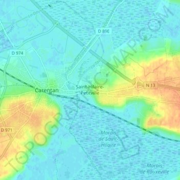
Naam: Topografische kaart Saint-Hilaire-Petitville, hoogte, reliëf.
Gemiddelde hoogte: 8 m
Minimale hoogte: -1 m
Maximale hoogte: 32 m
Andere topografische kaarten
Klik op een kaart om zijn topografie, zijn hoogte en zijn reliëf te bekijken.
Vierville
France > Normandie > Manche > Carentan-les-Marais
Vierville, Carentan-les-Marais, Saint-Lô, Manche, Normandie, France métropolitaine, 50480, France
Gemiddelde hoogte: 10 m
La Trouparderie
France > Normandie > Manche > Carentan-les-Marais > Saint-Hilaire-Petitville
La Trouparderie, Saint-Hilaire-Petitville, Carentan-les-Marais, Saint-Lô, Manche, Normandie, France métropolitaine, 50500, France
Gemiddelde hoogte: 8 m
Houesville
France > Normandie > Manche > Carentan-les-Marais
Houesville, Carentan-les-Marais, Saint-Lô, Manche, Normandie, France métropolitaine, 50480, France
Gemiddelde hoogte: 12 m
Montmartin-en-Graignes
France > Normandie > Manche > Carentan-les-Marais
Montmartin-en-Graignes, Carentan-les-Marais, Saint-Lô, Manche, Normandie, France métropolitaine, 50620, France
Gemiddelde hoogte: 15 m
Le Moulin à Vent
France > Normandie > Manche > Carentan-les-Marais > Brévands > Le Moulin à Vent
Le Moulin à Vent, Brévands, Carentan-les-Marais, Saint-Lô, Manche, Normandie, France métropolitaine, 50500, France
Gemiddelde hoogte: 8 m
Brévands
France > Normandie > Manche > Carentan-les-Marais
Brévands, Carentan-les-Marais, Saint-Lô, Manche, Normandie, France métropolitaine, 50500, France
Gemiddelde hoogte: 4 m
Saint-Pellerin
France > Normandie > Manche > Carentan-les-Marais
Saint-Pellerin, Carentan-les-Marais, Saint-Lô, Manche, Normandie, France métropolitaine, 50500, France
Gemiddelde hoogte: 23 m
Saint-Côme-du-Mont
France > Normandie > Manche > Carentan-les-Marais
Saint-Côme-du-Mont, Carentan-les-Marais, Saint-Lô, Manche, Normandie, France métropolitaine, 50500, France
Gemiddelde hoogte: 6 m