
Topografische kaart دهستان اندوهجرد
Interactieve kaart
Klik op de kaart om de hoogte weer te geven.
Over deze kaart
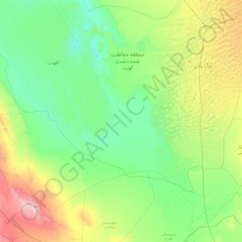
Naam: Topografische kaart دهستان اندوهجرد, hoogte, reliëf.
Gemiddelde hoogte: 565 m
Minimale hoogte: 151 m
Maximale hoogte: 2.378 m
Andere topografische kaarten
Klik op een kaart om zijn topografie, zijn hoogte en zijn reliëf te bekijken.
حوض نخعی
Iran > Kerman Province > Kerman County > Kerman
حوض نخعی, فارابی, Sarjangaldari Suburb, منطقه ۲, Kerman, بخش مرکزی شهرستان کرمان, Kerman County, Kerman Province, Iran
Gemiddelde hoogte: 1.758 m
lut lake
Iran > Kerman Province > Kerman County > دهستان تکاب
lut lake, دهستان تکاب, بخش شهداد, Kerman County, Kerman Province, Iran
Gemiddelde hoogte: 262 m
Shahdad
Iran > Kerman Province > Kerman County > Shahdad
Shahdad, بخش شهداد, Kerman County, Kerman Province, Iran
Gemiddelde hoogte: 452 m
دهستان تکاب
Iran > Kerman Province > Kerman County
دهستان تکاب, بخش شهداد, Kerman County, Kerman Province, Iran
Gemiddelde hoogte: 637 m
Mahan
Iran > Kerman Province > Kerman County
Mahan, بخش ماهان, Kerman County, Kerman Province, Iran
Gemiddelde hoogte: 1.944 m
Qanateghestan
Iran > Kerman Province > Kerman County
Qanateghestan, بخش ماهان, Kerman County, Kerman Province, Iran
Gemiddelde hoogte: 1.857 m
Lut Desert
Iran > Kerman Province > Kerman County > دهستان تکاب
Lut Desert, دهستان تکاب, بخش شهداد, Kerman County, Kerman Province, Iran
Gemiddelde hoogte: 709 m
Langar
Iran > Kerman Province > Kerman County > Mahan
Langar, Mahan, بخش ماهان, Kerman County, Kerman Province, Iran
Gemiddelde hoogte: 1.863 m