
Topografische kaart Lut Desert
Interactieve kaart
Klik op de kaart om de hoogte weer te geven.
Lut Desert
The eastern part of Dasht-e Lut is a low plateau covered with salt flats with lowest elevations around 110 m above sea level (30.398609 N, 58.493041 E). In contrast, the center has been sculpted by the wind into a series of parallel ridges and furrows, extending over 150 km (93 mi) and reaching 75 metres (246 ft) in height. This area is also riddled with ravines and sinkholes. The southeast is a vast expanse of sand, like a Saharan erg, with dunes 300 metres (980 ft) high, among the tallest in the world.
Over deze kaart
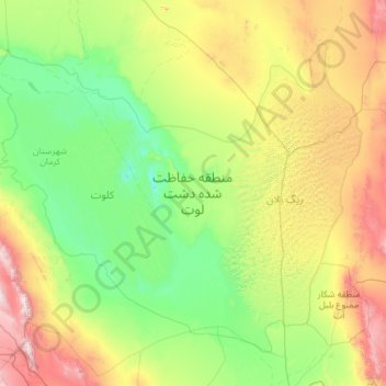
Naam: Topografische kaart Lut Desert, hoogte, reliëf.
Gemiddelde hoogte: 709 m
Minimale hoogte: 145 m
Maximale hoogte: 2.868 m
Andere topografische kaarten
Klik op een kaart om zijn topografie, zijn hoogte en zijn reliëf te bekijken.