
Topografische kaart Catlettsburg
Interactieve kaart
Klik op de kaart om de hoogte weer te geven.
Over deze kaart
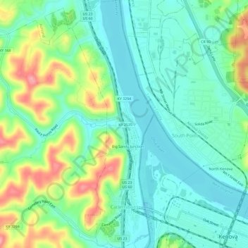
Naam: Topografische kaart Catlettsburg, hoogte, reliëf.
Locatie: Catlettsburg, Boyd County, Kentucky, United States (38.39726 -82.61267 38.44262 -82.59342)
Gemiddelde hoogte: 190 m
Minimale hoogte: 155 m
Maximale hoogte: 268 m
Andere topografische kaarten
Klik op een kaart om zijn topografie, zijn hoogte en zijn reliëf te bekijken.
Ironville
United States > Kentucky > Boyd County
Ironville, Boyd County, Kentucky, 41102, United States
Gemiddelde hoogte: 214 m
Westwood
United States > Kentucky > Boyd County > Fairview
Westwood, Fairview, Boyd County, Kentucky, United States
Gemiddelde hoogte: 192 m
Cannonsburg
United States > Kentucky > Boyd County
Cannonsburg, Boyd County, Kentucky, 41105, United States
Gemiddelde hoogte: 217 m
Ashland
United States > Kentucky > Boyd County
Ashland, Boyd County, Kentucky, 41101, United States
Gemiddelde hoogte: 196 m
Boltsfork
United States > Kentucky > Boyd County > Boltsfork
Boltsfork, Boyd County, Kentucky, United States
Gemiddelde hoogte: 241 m
Rush
United States > Kentucky > Boyd County
Rush, Boyd County, Kentucky, 41168, United States
Gemiddelde hoogte: 244 m