
Topografische kaart Area L (Lone Butte/Interlakes)
Interactieve kaart
Klik op de kaart om de hoogte weer te geven.
Over deze kaart
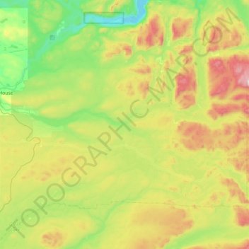
Naam: Topografische kaart Area L (Lone Butte/Interlakes), hoogte, reliëf.
Gemiddelde hoogte: 1.147 m
Minimale hoogte: 767 m
Maximale hoogte: 1.918 m
Andere topografische kaarten
Klik op een kaart om zijn topografie, zijn hoogte en zijn reliëf te bekijken.
Lone Butte
Canada > British Columbia > Cariboo Regional District > Area L (Lone Butte/Interlakes)
Lone Butte, Area L (Lone Butte/Interlakes), Cariboo Regional District, British Columbia, Canada
Gemiddelde hoogte: 1.159 m
Deka Lake
Canada > British Columbia > Cariboo Regional District > Area L (Lone Butte/Interlakes)
Deka Lake, Area L (Lone Butte/Interlakes), Cariboo Regional District, British Columbia, Canada
Gemiddelde hoogte: 1.141 m
Sheridan Lake
Canada > British Columbia > Cariboo Regional District > Area L (Lone Butte/Interlakes)
Sheridan Lake, Area L (Lone Butte/Interlakes), Cariboo Regional District, British Columbia, Canada
Gemiddelde hoogte: 1.127 m
Bridge Lake
Canada > British Columbia > Cariboo Regional District > Area L (Lone Butte/Interlakes)
Bridge Lake, Area L (Lone Butte/Interlakes), Cariboo Regional District, British Columbia, Canada
Gemiddelde hoogte: 1.158 m
Sulphurous Lake
Canada > British Columbia > Cariboo Regional District > Area L (Lone Butte/Interlakes) > Deka Lake
Sulphurous Lake, Deka Lake, Area L (Lone Butte/Interlakes), Cariboo Regional District, British Columbia, Canada
Gemiddelde hoogte: 1.168 m