Geolokaliseren

Topografische kaart Brambuk - The National Park and Cultural Centre Park

Interactieve kaart

Klik op de kaart om de hoogte weer te geven.

Over deze kaart

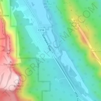
Naam: Topografische kaart Brambuk - The National Park and Cultural Centre Park, hoogte, reliëf.

Locatie: Brambuk - The National Park and Cultural Centre Park, Halls Gap, Shire of Northern Grampians, Victoria, 3381, Australia (-37.15910 142.52819 -37.15516 142.53112)

Gemiddelde hoogte: 372 m

Minimale hoogte: 223 m

Maximale hoogte: 732 m

Andere topografische kaarten

Klik op een kaart om zijn topografie, zijn hoogte en zijn reliëf te bekijken.

Boulder Rock

Australia > Victoria > Halls Gap

Boulder Rock, Halls Gap, Shire of Northern Grampians, Victoria, 3381, Australia

Gemiddelde hoogte: 304 m

Boroka Lookout

Australia > Victoria > Halls Gap

Boroka Lookout, Boroka Track, Halls Gap, Shire of Northern Grampians, Victoria, 3381, Australia

Gemiddelde hoogte: 614 m