
Topografische kaart Cumberland Gap
Interactieve kaart
Klik op de kaart om de hoogte weer te geven.
Over deze kaart
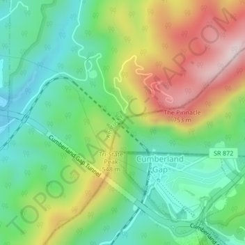
Naam: Topografische kaart Cumberland Gap, hoogte, reliëf.
Locatie: Cumberland Gap, Lee County, Virginia, 37724, United States (36.60399 -83.67369 36.60409 -83.67359)
Gemiddelde hoogte: 512 m
Minimale hoogte: 349 m
Maximale hoogte: 783 m
The V-shaped gap serves as a gateway to the west. The base of the gap is about 300 ft (91 m) above the valley floor, even though the north side of the pass was lowered 20 ft (6.1 m) during the construction of Old U.S. Route 25E. To the south, the ridge rises 600 ft (180 m) above the pass, while to the north the Pinnacle Overlook towers 900 ft (270 m) above (elevation 2,505 ft (764 m)).
Andere topografische kaarten
Klik op een kaart om zijn topografie, zijn hoogte en zijn reliëf te bekijken.
Dryden
United States > Virginia > Lee County > Dryden
Dryden, Lee County, Virginia, 24243, United States
Gemiddelde hoogte: 525 m
Ewing
United States > Virginia > Lee County
Ewing, Lee County, Virginia, United States
Gemiddelde hoogte: 482 m
Jonesville
United States > Virginia > Lee County
Jonesville, Lee County, Virginia, United States
Gemiddelde hoogte: 478 m
Stickleyville
United States > Virginia > Lee County > Stickleyville
Stickleyville, Lee County, Virginia, United States
Gemiddelde hoogte: 585 m
Edds Mill
United States > Virginia > Lee County > Edds Mill
Edds Mill, Lee County, Virginia, 24281, United States
Gemiddelde hoogte: 465 m
Pennington Gap
United States > Virginia > Lee County
Pennington Gap, Lee County, Virginia, 24277, United States
Gemiddelde hoogte: 481 m