
Topografische kaart Saslonch - Langkofel - Sassolungo
Interactieve kaart
Klik op de kaart om de hoogte weer te geven.
Over deze kaart
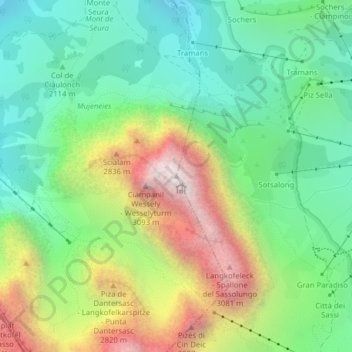
Naam: Topografische kaart Saslonch - Langkofel - Sassolungo, hoogte, reliëf.
Gemiddelde hoogte: 2.320 m
Minimale hoogte: 1.837 m
Maximale hoogte: 3.179 m
Andere topografische kaarten
Klik op een kaart om zijn topografie, zijn hoogte en zijn reliëf te bekijken.
Secёda - Monte Seceda
Italie > Trentin-Haut-Adige > Haut-Adige > Santa Cristina Gherdëina - St. Christina in Gröden - Santa Cristina Valgardena
Secёda - Monte Seceda, Santa Cristina Gherdëina - St. Christina in Gröden - Santa Cristina Valgardena, Salten-Schlern - Salto-Sciliar, Haut-Adige, Trentin-Haut-Adige, 39047, Italie
Gemiddelde hoogte: 2.106 m