
Topografische kaart South Branch Muskoka River;Spence Lake
Interactieve kaart
Klik op de kaart om de hoogte weer te geven.
Over deze kaart
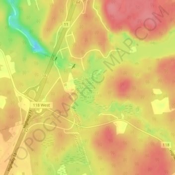
Naam: Topografische kaart South Branch Muskoka River;Spence Lake, hoogte, reliëf.
Gemiddelde hoogte: 275 m
Minimale hoogte: 217 m
Maximale hoogte: 303 m
Andere topografische kaarten
Klik op een kaart om zijn topografie, zijn hoogte en zijn reliëf te bekijken.
Crosson Lake
Canada > Ontario > Muskoka District > Bracebridge
Crosson Lake, Bracebridge, District Municipality of Muskoka, Muskoka District, Central Ontario, Ontario, Canada
Gemiddelde hoogte: 339 m
Bonnie Lake
Canada > Ontario > Muskoka District > Bracebridge
Bonnie Lake, Bracebridge, District Municipality of Muskoka, Muskoka District, Central Ontario, Ontario, Canada
Gemiddelde hoogte: 321 m
McKay Lake
Canada > Ontario > Muskoka District > Bracebridge
McKay Lake, Bracebridge, District Municipality of Muskoka, Muskoka District, Central Ontario, Ontario, Canada
Gemiddelde hoogte: 314 m