
Topografische kaart El Encanto
Interactieve kaart
Klik op de kaart om de hoogte weer te geven.
Over deze kaart
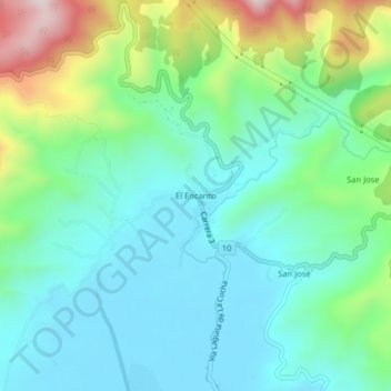
Naam: Topografische kaart El Encanto, hoogte, reliëf.
Locatie: El Encanto, Pasto, Centro, Nariño, RAP Pacífico, Colombia (1.14269 -77.17631 1.18269 -77.13631)
Gemiddelde hoogte: 2.919 m
Minimale hoogte: 2.779 m
Maximale hoogte: 3.317 m
Andere topografische kaarten
Klik op een kaart om zijn topografie, zijn hoogte en zijn reliëf te bekijken.
Isla de la Corota
Isla de la Corota, Pasto, Centro, Nariño, Colombia
Gemiddelde hoogte: 2.786 m
Perímetro Urbano Pasto
Perímetro Urbano Pasto, Pasto, Centro, Nariño, RAP Pacífico, Colombia
Gemiddelde hoogte: 2.676 m
Comuna 9
Colombia > Nariño > Pasto > Perímetro Urbano Pasto
Comuna 9, Perímetro Urbano Pasto, Pasto, Centro, Nariño, RAP Pacífico, Colombia
Gemiddelde hoogte: 2.617 m