
Topografische kaart Rewalsar
Interactieve kaart
Klik op de kaart om de hoogte weer te geven.
Over deze kaart
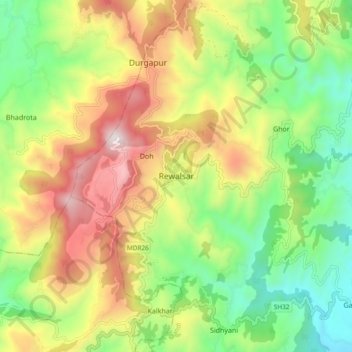
Naam: Topografische kaart Rewalsar, hoogte, reliëf.
Gemiddelde hoogte: 1.283 m
Minimale hoogte: 814 m
Maximale hoogte: 1.927 m
Rewalsar is located at an altitude of 1360 m above sea level. It is connected to Mandi by a motorable road and is about 25 km from Mandi. Lying in the Southern Himalayan belt, winters in Rewalsar can be freezing, while summers are generally pleasant.