
Topografische kaart Winterthur
Interactieve kaart
Klik op de kaart om de hoogte weer te geven.
Over deze kaart
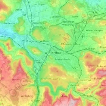
Naam: Topografische kaart Winterthur, hoogte, reliëf.
Locatie: Winterthur, Bezirk Winterthur, Zurich, Switzerland (47.44972 8.65661 47.54800 8.80994)
Gemiddelde hoogte: 504 m
Minimale hoogte: 390 m
Maximale hoogte: 696 m
Winterthur is located at an elevation of 439 meters (1,440 ft). The city is located in a basin south and east of the river Töss before it meets the High Rhine after 10 kilometers. The Eulach, a small river, flows from the town's east end through the middle of the town to meet the Töss at the west exit of the city. Because of this the town is colloquially also called "Eulachstadt". Zürich lies about 20 km (12 mi) southwest of Winterthur.
Andere topografische kaarten
Klik op een kaart om zijn topografie, zijn hoogte en zijn reliëf te bekijken.
Ellikerbach
Switzerland > Zurich > Bezirk Winterthur > Ellikon an der Thur
Ellikerbach, Untergris, Ellikon an der Thur, Bezirk Winterthur, Zurich, 8548, Switzerland
Gemiddelde hoogte: 400 m