
Topografische kaart Stanwell
Interactieve kaart
Klik op de kaart om de hoogte weer te geven.
Over deze kaart
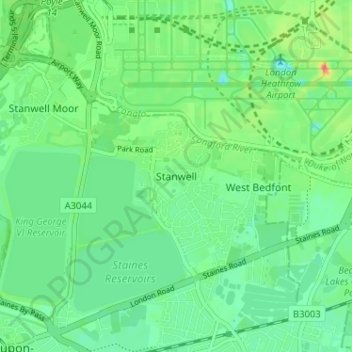
Naam: Topografische kaart Stanwell, hoogte, reliëf.
Gemiddelde hoogte: 20 m
Minimale hoogte: -1 m
Maximale hoogte: 64 m
Andere topografische kaarten
Klik op een kaart om zijn topografie, zijn hoogte en zijn reliëf te bekijken.
Charlton
United Kingdom > England > Surrey > Borough of Spelthorne
Charlton, Borough of Spelthorne, Surrey, England, TW17 0ST, United Kingdom
Gemiddelde hoogte: 13 m
Laleham
United Kingdom > England > Surrey > Borough of Spelthorne
Laleham, Borough of Spelthorne, Surrey, England, TW18 1SD, United Kingdom
Gemiddelde hoogte: 14 m
Upper Halliford
United Kingdom > England > Surrey > Borough of Spelthorne
Upper Halliford, Borough of Spelthorne, Surrey, England, TW17 8SQ, United Kingdom
Gemiddelde hoogte: 13 m
Pharaoh's Island
United Kingdom > England > Surrey > Borough of Spelthorne
Pharaoh's Island, Borough of Spelthorne, Surrey, England, TW17 9LN, United Kingdom
Gemiddelde hoogte: 14 m
Shepperton
United Kingdom > England > Surrey > Borough of Spelthorne
Shepperton, Borough of Spelthorne, Surrey, England, United Kingdom
Gemiddelde hoogte: 12 m
Ashford
United Kingdom > England > Surrey > Borough of Spelthorne
Ashford, Borough of Spelthorne, Surrey, England, United Kingdom
Gemiddelde hoogte: 16 m