
Topografische kaart Seminole County
Interactieve kaart
Klik op de kaart om de hoogte weer te geven.
Over deze kaart
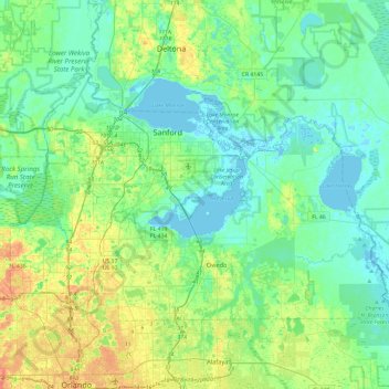
Naam: Topografische kaart Seminole County, hoogte, reliëf.
Locatie: Seminole County, Florida, United States of America (28.61051 -81.45974 28.87923 -80.98699)
Gemiddelde hoogte: 14 m
Minimale hoogte: -3 m
Maximale hoogte: 53 m
Andere topografische kaarten
Klik op een kaart om zijn topografie, zijn hoogte en zijn reliëf te bekijken.
West Palm Beach
United States of America > Florida > West Palm Beach
West Palm Beach, Palm Beach County, Florida, 33401, United States of America
Gemiddelde hoogte: 4 m
St. Johns County
United States of America > Florida
St. Johns County, Florida, United States of America
Gemiddelde hoogte: 6 m
Miami-Dade County
United States of America > Florida
Miami-Dade County, Florida, United States of America
Gemiddelde hoogte: 3 m
Hillsborough County
United States of America > Florida
Hillsborough County, Florida, United States of America
Gemiddelde hoogte: 20 m
Collier County
United States of America > Florida
Collier County, Florida, United States of America
Gemiddelde hoogte: 5 m