
Topografische kaart Jena
Klik op de kaart om de hoogte weer te geven.
Jena
Jena is situated in a hilly landscape in eastern Thuringia at the Saale river, between the Harz mountains 85 km (53 mi) in the north, the Thuringian Forest/Thuringian Highland 50 km (31 mi) in the southwest and the Ore Mountains, 75 km (47 mi) in the southeast. The municipal terrain is hilly with rugged slopes at the valley's edges. The city centre is situated at 160 m of elevation, whereas the mountains on both sides of Saale valley rise up to 400 m. On the eastern side those are (from north to south): the Gleisberg near Kunitz, the Jenzig near Wogau, the Hausberg near Wenigenjena, the Kernberge near Wöllnitz, the Johannisberg near Lobeda and the Einsiedlerberg near Drackendorf. On the western side, there are the Jägersberg near Zwätzen, the Windknollen north of the city centre, the Tatzend west of the city centre, the Lichtenhainer Höhe near Lichtenhain, the Holzberg near Winzerla, the Jagdberg near Göschwitz and the Spitzenberg near Maua. The mountains belong to the geological formation of Ilm Saale Plate (Muschelkalk) and are relatively flat on their peaks but steep to the valleys in between. Due to its jagged surface, the municipal territory isn't very suitable for agriculture all the more since the most flat areas along the valley were built on during the 20th century. At the mountains is some forest of different leaf trees and pines.
Over deze kaart
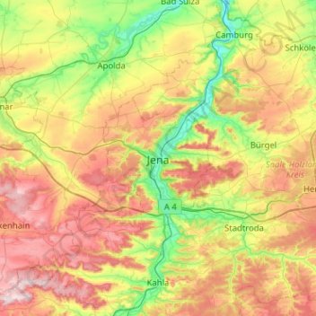
Naam: Topografische kaart Jena, hoogte, reliëf.
Locatie: Jena, Thuringia, 07743, Germany (50.76817 11.42794 51.08817 11.74794)
Gemiddelde hoogte: 289 m
Minimale hoogte: 121 m
Maximale hoogte: 524 m
Andere topografische kaarten
Klik op een kaart om zijn topografie, zijn hoogte en zijn reliëf te bekijken.