
Topografische kaart Santa Catalina Island
Interactieve kaart
Klik op de kaart om de hoogte weer te geven.
Over deze kaart
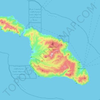
Naam: Topografische kaart Santa Catalina Island, hoogte, reliëf.
Gemiddelde hoogte: 60 m
Minimale hoogte: 0 m
Maximale hoogte: 637 m
Catalina is primarily composed of two distinct rock units: Catalina Schist from the Early Cretaceous (95 to 109 million years ago), and Miocene volcanic and intrusive igneous rocks. The island is rich in quartz, to the extent that some beaches on the seaward side have silvery-grey sand. These formations originally occurred on the ocean floor and emerged from the ocean through tectonic activity. This means that the Santa Catalina Island land-mass was never directly connected to mainland California. Other geologic factors that contributed to the island topography include further geologic uplift and subsidence, tectonic plate movement, sedimentation, metamorphic activity, weathering, and erosion.